8.1 Oughterard Small Growth Town
8.2 Town Context
The town of Oughterard is located approximately 27km north-west of Galway City via the N59 Galway – Clifden Road, which is a National Primary Route. Oughterard is designated as a Small Growth Town in the Galway County Development Plan 2022 – 2028 by virtue of the population of the town and the extensive level of local services, employment and residential stock that it offers to residents. It also serves a large rural catchment area stretching further westwards towards the town of Clifden and eastwards in the direction of the town of Maigh Cuilinn.
The town is built on the banks of the Owenriff River with the Main Street, a linear settlement pattern developing in an easterly direction. Building heights vary along the N59 within the town from bungalow up to two storeys generally. The main street of the town offers inhabitants a wide variety of local services such as convenience type shopping, bank, post office, restaurants and pubs. Other local services such as schools, playing pitches, health centre and playground are all located within short walking distance of the Main Street. These local services also provide employment opportunities in the town. There are also office and industrial uses which provide further and more varied employment prospects.
8.3 Sustainable Communities
8.3.1 Housing
There is a wide variety of housing developments in and around the town of Oughterard. These house types include a range of terraced and detached housing that are both bungalow and two storeys, located along the N59 arterial route through the town centre. For the most part, these properties do not have front gardens as they typically tend to abut the public footpath that serves the town, however, there are exceptions to this with some properties along this route having small front garden areas. This part of the town also includes instances of first floor residential accommodation – a ‘living over the shop’ accommodation type.
Suburban type housing developments are located principally to the north and south of the N59. They also vary is design, layout and dwelling type. They include a range of terraced, mid terraced and semi- detached properties. Typically, these dwelling houses have been constructed on rectangular shaped plots with modest front and rear garden areas. The larger housing developments include areas of communal green space within each.
A key purpose of this settlement plan will be to provide additional housing development into the future that conforms to the principles of quality and sustainability in terms of design and layout particularly. The settlement plan and accompanying County Development Plan provides information and guidance pertaining to development for the next six years up to 2028. This information includes details of the optimum future location, type and design of future residential development in and around the town of Oughterard.
8.3.2 Education
In terms of education, Scoil Naomh Pól is a co-educational secondary school. The school is located on the western side of the Carrowmanagh Road – a short distance from the primary school, as such it acts as a feeder school.
The national school Scoil Chuimín & Caitríona is located on the eastern side of Carrowmanagh Road, which is north of the N59 Galway Clifden Road
8.3.3 Community Facilities
Oughterard is well served by community facilities. These facilities range from full size sports pitches of varying types to a children’s playground and include other facilities such as creche, primary school, secondary school, church and graveyard, medical facilities including dentist and optician, Garda Station, Credit Union, Post Office, bank shops, butcher, hair dresser, builders yard and nursing home.
The town has a wide and varied selection of community uses. It also exhibits good examples of building reuse, for example a former school building is now used as a community hall and the former courthouse building in the town is now used as a library serving the local community. The town is fortunate to have a locally based resource centre which offers a variety of supports and services to the local community.
Walks and trails are also a valued community facility within and around Oughterard Town. Oughterard GAA Club is located towards the eastern end of the town to the north of the N59. These grounds comprise of playing pitches and a club house with a walking track around the perimeter of the site. Corribdale Park, a fitness and recreation park for the local community is located adjacent to the GAA grounds. It includes a secure playground area for smaller children. Oughterard Rugby Club is located towards the western end of the town, which is also a much-valued community facility to local residents.
8.3.4 Environment and Heritage
The origins of the town of Oughterard are based on the intersection of the fertile, limestone based farmland to the south and east of the town. The more rugged and bare Conamara landscape begins to the north and west of Oughterard. The development of the town at this intersection was also influenced with the presence low level river crossing point which is a typical geographical feature that tends to influence settlement location. The road network serving the town was significantly improved in the early 19th century. Today the town still exhibits a range of buildings that were developed for administrative purposes. Examples of these include the courthouse and the two church buildings in the town. The street pattern and architectural variety of buildings, both designed and vernacular creates a streetscape which reflects its history. Future development should reflect and respect its established character in terms of plot size, height, material and density. The existing Architectural Conservation Area in Oughterard will be retained and proposed development within the lifetime of this plan will be required to respect the architectural qualities of this ACA. There are a number of protected structures in the town, namely O’Fatharta Restauran/Halloran’s, Kilcummin Parish Church
The Former Courthouse building, the road Bridge over the Owenriff river and the Church of the Immaculate Conception.
Oughterard also has a number of Recorded Monuments and there are two Natura 2000 sites-Lough Corrib SAC and Lough Corrib SPA and National Heritage Areas.
8.3.5 Employment, Economic and Tourism Development
Oughterard is an attractive place to visit and holiday. As such the tourism industry makes a significant contribution to the town’s economy. The town has evolved as a place for tourists to visit given its accessibility from Galway City via the N59 and the location of the town at the gateway to the Conamara Region. The town also benefits from an attractive landscape in close proximity to Lough Corrib. Both of these features make Oughterard an attractive place to visit and spend time. It offers a wide variety of attractions and therefore appeals to a wider range of visitors. The proximity of Lough Corrib to Oughterard provides a welcome economic boost to the area as this water body offers both locals and visitors to the area a range of water-based activities, which include boat trips and angling.
Pubs, shops, restaurants and venues providing overnight accommodation are just some of the beneficiaries of the tourist industry in Oughterard. A range of much needed employment options are therefore provided for people to avail of locally. However, much of the tourism based economic development and employment generated is seasonal and the summer season in this part of County Galway can be short lived.
Other employment sources in the town of Oughterard include office/service type employment along with some industrial employment. However, the town could support a larger employment base locally in favour of residents commuting to Galway City each day. There is employment potential within the settlement plan area, in particular the Town Centre, Business and Enterprise and Industrial zonings. Further employment opportunities and diversification will be encouraged where appropriate.
The site of the former Oughterard Train Station, located towards the southern periphery of the settlement plan area has a zoning designation of business and enterprise. The existing train station building remains on site and it currently is actively in use as a carpet factory. The original train station is a nineteenth century building. It forms part of the Register of Protected Structures of the County Development Plan.
8.3.6 Town Centre/Retail
Oughterard enjoys a reasonably busy Town Centre. Some of the commercial buildings within the town centre zoning area are set within large developable plots which offer the potential to transform the provision of town centre and retail services in Oughterard over the lifetime of this plan. The town centre offers a variety of commercial services to local residents and visitors to the area. There is also a good range of pubs, cafés and restaurants to cater for people’s needs.
The Owenriff River runs parallel to the Main Street in the town. Positioned north of the Main Street the areas of land that are prone to flooding have been zoned as Open Space/Recreation and Amenity. However, where flooding is not an issue, some town centre zoned plots stretch northwards to the banks of this watercourse. This offers the potential for the re-development of these town centre plots and tailoring the orientation of new development towards the local attractiveness of the Owenriff River.
The Town Centre zoning abuts and includes areas that are used for existing residential purposes and community facilities. As such the town centre not only provides those in the area with commercial shopping services but also professional services and local facilities. All of these uses in such close proximity to each other ensure a busy and thriving town centre atmosphere.
8.4 Services and Infrastructure
8.4.1 Water Services
Oughterard receives its water supply from the Oughterard Town Supply Scheme. All of the lands identified for development potential are served by public water supply.
8.4.2 Wastewater Disposal
Oughterard is partly serviced by a public wastewater treatment plant. All of the lands identified for development potential are served by public wastewater services.
8.4.3 Transportation and Movement
The National Primary Route the N59 is the main route that traverses the town in an east-west direction. There have been various realignment works carried out on the N59 which make Oughterard more accessible from Galway City. The town is also served by a number of bus services from Galway and westbound towards and beyond Clifden SGT. The town is served with public lighting and footpaths to accommodate ease of pedestrian movement. There are also walking trails which attract visitors to the town and surrounding area. Residential development in this settlement plan encourages sustainable transport links to the main shopping streets and community facilities such as the schools and sports playing pitches in the area. This approach to land use zoning and a sequential approach to development thereof should encourage and promote a reduction in reliance on the private car.
Oughterard is served with public transport bus services that provide connections to Galway City and Clifden. The bus stop is located within the town centre which is accessible to the surrounding residential areas within the plan area.
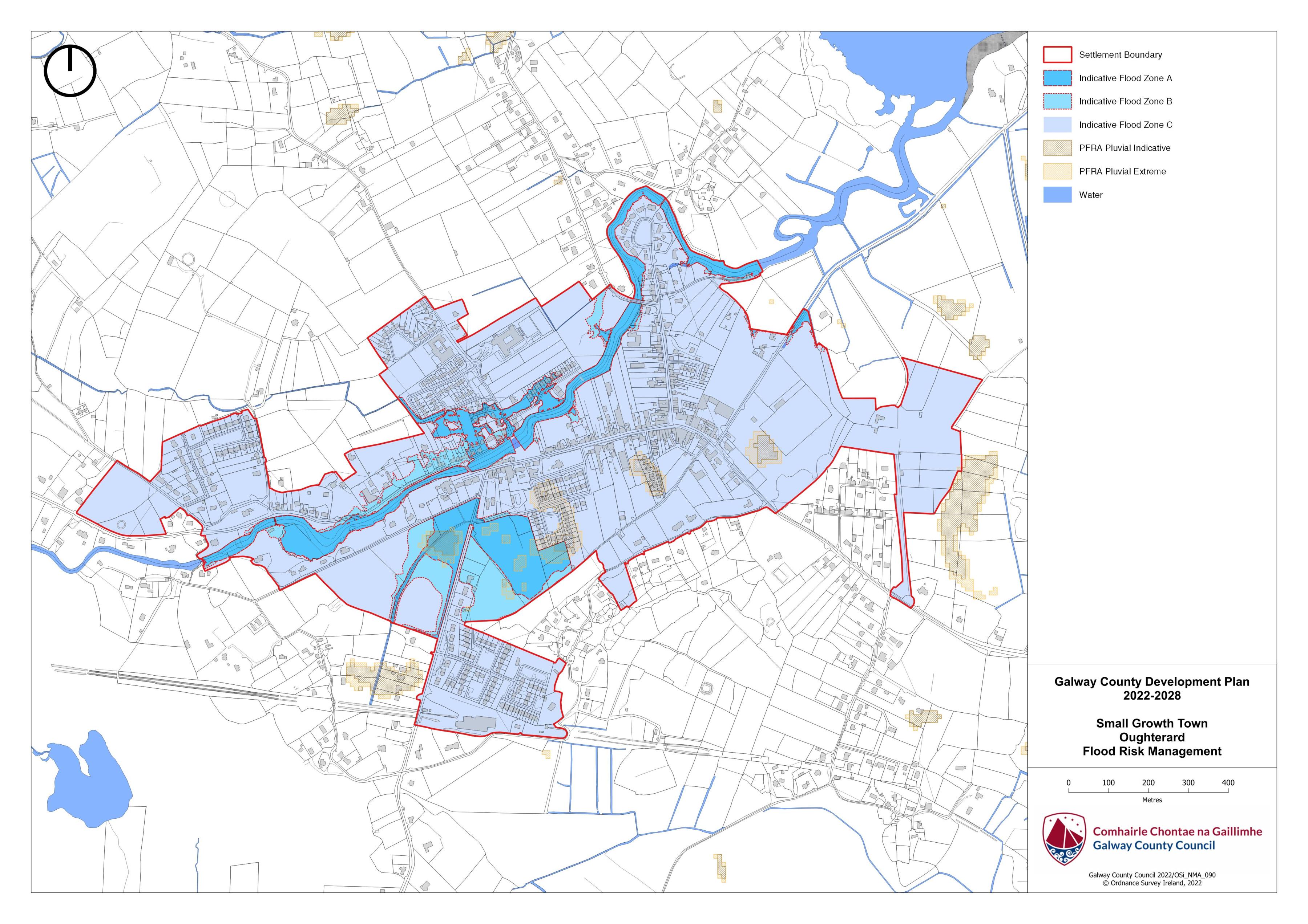
8.5 Flooding
With respect to lands within the village that are liable to flood risk, the Council will require any proposed developments to comply with ‘The Planning System and Flood Risk Management Guidelines for Planning Authorities (DEHLG, 2009) and Circular PL2/2014 and any amendment thereof. The Council, having regard to the nature and scope of development, may require the submission of Flood Risk Assessments, as appropriate, to assess the suitability of development proposals. There is a flood map identified for Oughterard and it is in accordance with the guidelines and circular referenced above.
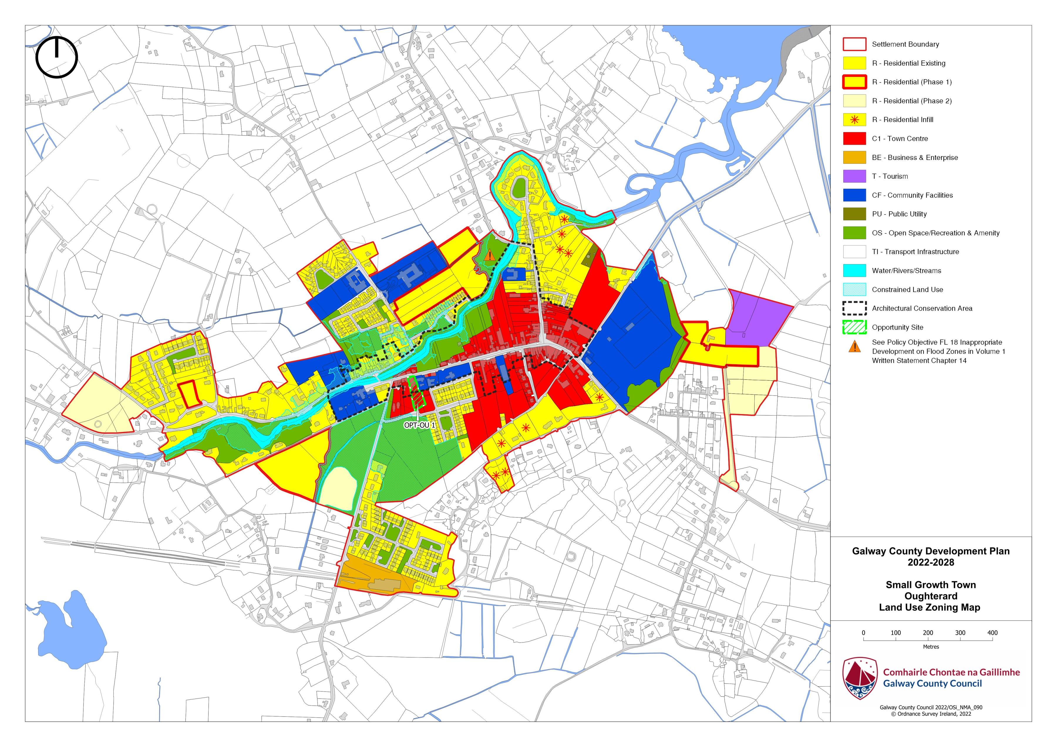
|
Land Use Zoning Policy Objectives for Oughterard (Oughterard Small Growth Town-OSGT) |
|---|
|
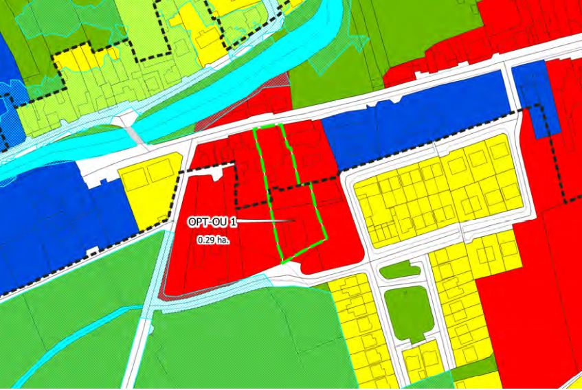
OSGT 1 Sustainable Town Centre Promote the development of Oughterard, as an intensive, high quality, well landscaped, human-scaled and accessible environment, with an appropriate mix of uses, including residential, commercial, service, tourism, enterprise, public and community uses as appropriate, that provide a range of retail services, facilities and amenities to the local community and visitors. The town centre and associated main street shall remain the primary focus for retail and service activity within these plan areas. OSGT 2 Sustainable Residential Communities Promote the development of appropriate and serviced lands to provide for high quality, well laid out and well landscaped sustainable residential communities with an appropriate mix of housing types and densities, together with complementary land uses such as community facilities, local services and public transport facilities, to serve the residential population of Oughterard settlement plan. Protect existing residential amenities and facilitate compatible and appropriately designed new infill development, in accordance with the proper planning and sustainable development of the plan area. Specifically encourage living over the shop which can contribute to the vitality of the core and extend activity beyond business hours. OSGT 3 Community Facilities and Services To encourage and support the expansion and development of existing facilities and services to meet the needs of the local community. OSGT 4 Business and Enterprise (a) To facilitate the expansion of business and enterprise uses in the plan area of Oughterard where appropriate and in accordance with the proper planning and development of the area. (b) Promote additional business and enterprises uses on the former train station site in Oughterard in accordance with the proper planning and development of the area. OSGT 5 Industrial Promote the expansion where appropriate of industrial and industrial related uses, including manufacturing, processing of materials, warehousing and distribution on suitable lands, with adequate services and facilities and a high level of access to the major road networks and public transport facilities. Adequate edge treatment and/or screening will be required to ensure high quality interfaces with public spaces and any adjoining residential areas or other sensitive land uses, as appropriate. OSGT 6 Tourism Development a) Promote and facilitate the further development of Ougherard as a key tourist destination for the benefit of the town and its surrounding areas. b) To support and facilitate in co-operation with relevant bodies and landowners, the provision of tourism amenity routes around the town. c) Encourage and assist the development of the sustainable tourism potential within Oughterard in a manner that respects, builds on, protects and enhances the cultural, built, architectural, archaeological and heritage significance of the town including natural heritage and biodiversity, and its local amenities in particular with the local fishing tourism market which is unique for Oughterard. OSGT 7 Public Infrastructure Support and encourage infrastructural development and improvement works that benefit Oughterard as an SGT and the wider Region. OSGT 8 Pedestrian and Cycle Network Encourage and support the development of a series of pedestrian and cycle routes linking the residential areas to the town centre and local community services, where feasible. OSGT 9 Opportunity Site To promote and encourage the appropriate development of the opportunity site identified in this plan to positively contribute to the vitality and character of Oughterard. OSGT 10 Inappropriate Development on Flood Zones Where a development/land use is proposed within any area subject to this objective the development proposal will need to be accompanied by a detailed hydrological assessment and robust SUDS design which demonstrates the capacity to withstand potential flood events to maintain water quality and avoid potential effects to ecological features.
|
OPT-OU1 – Former Corrib House Hotel, Oughterard
|
Oughterard Land Use Zoning Map
Oughterard Flood Risk Management Map