please find submission attached
13.1 Ballygar Small Growth Village
Closed20 May, 2021, 09:00 - 30 Jul, 2021, 16:30
13.2 Village Context
Ballygar is located in north-east County Galway, 3KM from the border with County Roscommon to the east and 15KM from Mountbellew to the south-west via the N63. The village developed as a market town which dates back to the 19th Century. Evidence of the market town can be seen today with the wide main street and market square. The village settlement is a linear type development on the N63. The village is small and rural in character and located in a sparsely populated area of County Galway, however, it is served by a number of local services, which include shops, schools, cafes and sporting facilities.
13.3 Sustainable Communities
13.3.1 Housing
Housing in the village centre comprises a mix of single and two storeys, terraced and detached dwelling houses along the main street. The building stock forms a continuous and largely linear built up form with the focal point at Market Square and development extending north and south of Main Street.
The established housing stock fronting onto the Square, Main Street and the village core are modest in size, attractive and of traditional form and design with a high-density layout. There are a small number of suburban-type housing developments to the north and south of the village equating to a total of approximately 120 units of Ballygar’s new housing stock. They include detached, semi-detached and terraced dwelling houses with varying densities. The variety of dwellings that exist in the village provide a good mix for its inhabitants.
The settlement would benefit from regeneration of and re-use of existing properties within the village core. New developments should be well integrated with the existing village and allow for easy and safe access to the centre and main facilities by foot and bicycle. Development which utilises brownfield sites should be prioritised and all development should be sympathetic to the character of the area.
Continued renewal of properties within the Village Core is desirable and a high standard of design for infill housing development and new or replacement shop-fronts should be in keeping with the overall character of the main street.
13.3.2 Education
In terms of education, Scoil Mhuire Gan Smál (Ballygar National School) is a co-education primary school and Coláiste Mhuire is a co-educational, post-primary school.
13.3.3 Community Facilities
One of the primary functions of this village is to provide for the everyday needs of the local community. Social and community facilities play an important function in promoting social inclusion and act as a focal meeting point for residents of all ages.
The village has some well-developed community and recreation facilities including a church, commercial retail units, post office, community hall, sports pitch and public houses.
The large old school building (dated 1880) set at north end of the square is well placed opposite the Catholic Church. The courthouse located just east of Saint Mary’s Church has recently been converted to a community space.
The local GAA club is St Brendan’s GAA, which is located within the village centre just north of the Square. This plan will seek to protect from development the existing community facilities and where possible expand the range of community facilities available in the village.
Ballygar is designated as a Category B (population of 201 to 1,000) village under the Tidy Towns annual competition. The local Tidy Towns group are very active in the enhancement of the village and its environs.
There are footpaths and public lighting within the village but limited traffic calming works have been carried out at gateway points. Traffic calming works are required to improve pedestrian safety around the Square, Scoil Mhuire Gan Smál /playground and at the crossroads to the east of the village near St Mary’s Secondary School.
The settlement is accessible by a daily Roscommon to Galway public transport (bus) service, that links the settlement to Galway City and also other areas including Mountbellew.
The population has increased in the settlement and surrounding hinterland in recent years and this in turn has put extra demands on the village’s infrastructure and community facilities. It is important that new facilities are encouraged to locate within the village cores and that where possible, existing community facilities are improved.
13.3.4 Environment and Heritage
Ballygar has an attractive streetscape that contains a number of fine individual buildings. St. Mary’s Catholic Church, the Bank of Ireland, Courthouse, located within the village are entered in the Record of Protected Structures and add to the architectural character of the settlement.
The market square provides an attractive area of open space for residents and the recently constructed band stand provides an attractive focal point. Since 1945 it has been used to hold the annual carnival. In recent years the area is also used as an informal car park at present and is sparsely planted with trees. Several different approaches could be taken to improve and enhance the public realm and visual appearance of the market square such as the addition of an outdoor seating area for residents and visitors to create a more attractive, people-friendly destination.
It is important to protect the permeability, structure and morphology of the village. The core area has been designated an Architectural Conservation Area. The unique built environment of the Village of Ballygar reflects its history in the pattern of the urban spaces and the design of the individual houses and landmark buildings. Ballygar has a diamond shaped terminus to the east of the Village, where the Protestant church once stood at the entrance to the former Castlekelly estate. Castle Kelly was a large and prosperous estate whose owner encouraged the market activity of the Village in the early 19th century.
The orderly planning of the Village has resulted in a wide main street flanked by predominantly two storey houses which present varied facades with moulded surrounds to windows and doors.
The recent insertion of a band stand reflects the association of the Village as the birthplace of Patrick Sarsfield Gilmore who was born in Ballygar in 1829 who is a leading composer and bandmaster in the USA. The courthouse has been brought back into community use through the commitments of the local people to the built heritage of their Village.
13.3.5 Village Centre and Business & Enterprise
Ballygar provides a limited amount of local employment and services to the people of the village and those within its hinterland and the plan will seek to support the development, vitality and vibrancy of the village.
Within the village core the aim is to bring the vacant and unused buildings into productive use. There is limited capacity for small residential schemes or self-built opportunities within the core. However, there are opportunities within the settlement for the redevelopment of existing underutilised properties and derelict dwellings to the east of the village. Development proposals locating within the village core will be supported and facilitated where appropriate especially Living Over the Shop Opportunities in the village core.
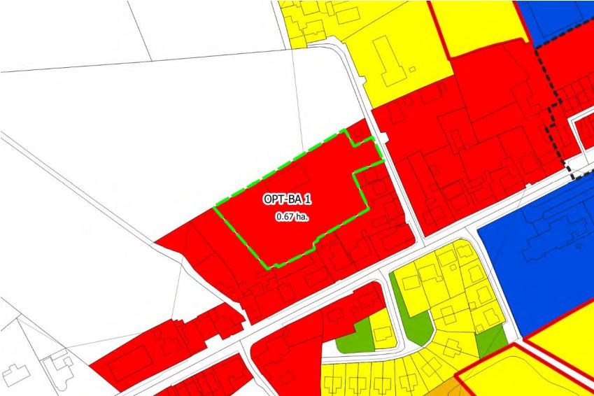
There are two opportunity sites located along the main street in Ballygar. There is a robust, albeit small commercial base within the village that serves the local population.
Ballygar’s proximity to the Suck Valley with quiet country lanes, bog roads, built, natural and cultural heritage would allow for tourist opportunities to be developed within the village.
13.4 Services and Infrastructure
13.4.1 Water Supply
Public water supply available. The village is served by a public water supply. All lands identified for development potential are served by public water supply and there is capacity in the network.
13.4.2 Waste Water
The village is served by a municipal wastewater treatment system. Works are required to take place on the system within the lifetime of the plan, however it is expected that this will commence in short term.
13.4.3 Transportation and Movement
The National Road the N63, runs through the settlement, giving rise to large volumes of traffic, including a high proportion of heavy goods vehicles. Additional traffic calming measures are required within the settlement.
There is ample on-street parking in designated car parking spaces l located in the square and along Main Street.
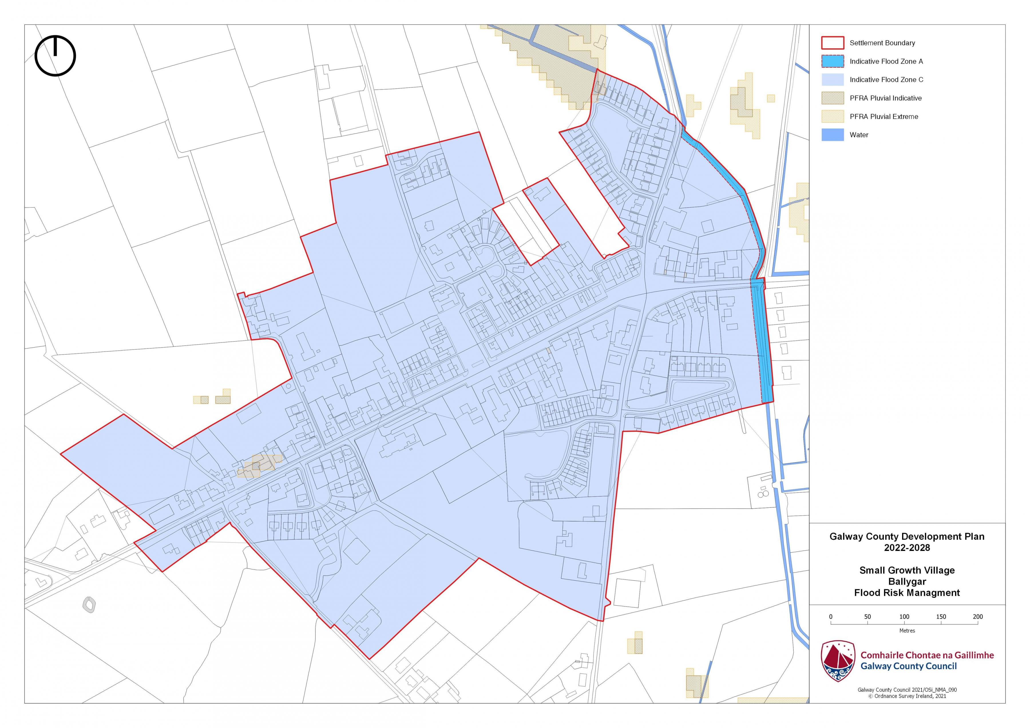
13.5 Flooding
With respect to lands within the village that are liable to flood risk, the Council will require any proposed developments to comply with ‘The Planning System and Flood Risk Management Guidelines for Planning Authorities (DEHLG, 2009) and Circular PL2/2014 and any amendment thereof. The Council, having regard to the nature and scope of development, may require the submission of Flood Risk Assessments, as appropriate, to assess the suitability of development proposals. There is a flood map identified for Ballygar and is in accordance with the guidelines and circular referenced above.
|
Land Use Zoning Policy Objectives for Ballygar (Ballygar Small Growth Village-BSGV) |
|
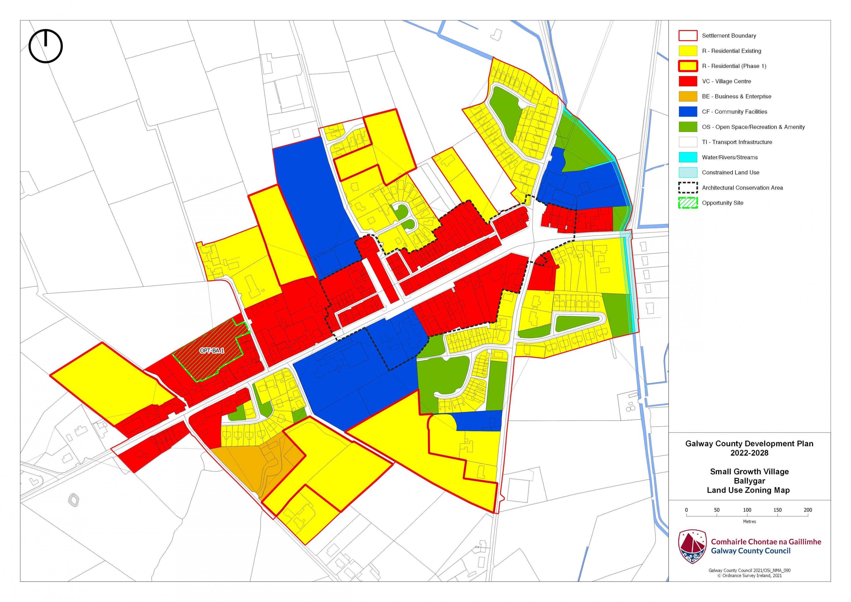
BSGV 1 Sustainable Village Centre Promote the development of Ballygar village, as an intensive, high quality, well landscaped, human-scaled and accessible environment, with an appropriate mix of uses, including residential, commercial, service, tourism, enterprise, public and community uses as appropriate, that provide a range of retail services, facilities and amenities to the local community and visitors to the villages. The village centre and associated main street shall remain the primary focus for retail and service activity within these plan areas. BSGV 2 Sustainable Residential Communities Promote the development of appropriate and serviced lands to provide for high quality, well laid out and well landscaped sustainable residential communities with an appropriate mix of housing types and densities, together with complementary land uses such as community facilities, local services and public transport facilities, to serve the residential population of Ballygar settlement plan. Protect existing residential amenities and facilitate compatible and appropriately designed new infill development, in accordance with the proper planning and sustainable development of the plan area. Specifically encourage living over the shop which can contribute to the vitality of the core and extend activity beyond business hours. BSGV 3 Local Development and Services To encourage and support the development of local facilities and services to meet the needs of the local community. BSGV 4 Playground Facilities To support the maintenance of playground facilities, subject to resources being available. BSGV 5 Small Scale Enterprises To encourage the provision of commercial and employment development within the village and in particular the provision of opportunities for small scale start up enterprises. BSGV 6 Streetscape Enhancement Works To seek to facilitate the preparation of a public realm plan that will inform streetscape enhancement works subject to resources being available. BSGV 7 Expansion of Public Infrastructure To support the expansion of public infrastructure within the village as required. BSGV 8 Opportunity Site To promote and encourage the appropriate re-development of the opportunity site identified in this plan, which will contribute to the vitality and character of Ballygar. |
|
OPT-BA 1 Opportunity Site Ballygar Brief Description Derelict shed in Ballygar. Area: The site area measures 0.67HA. Zoning: The site is zoned Village Centre. Current Land-Use: Vacant warehouse type shed. May have been used with the adjacent water tower. Opportunity: To provide for a mix of uses capable of accommodating retail and or commercial development. The main access to this site is via a small laneway to the east of the site adjacent to existing residential properties. A mix of commercial and residential uses may be appropriate here.
|
Ballygar Land Use Zoning Map
Ballygar Flood Risk Management Map
Contents
References
Observations
Observations