Dréacht Phlean Forbartha na Gaillimhe 2022-2028
Aighneacht ó Oifigeach Pleanála Teanga na Ceathrún Rua
1. Moltar go bhforbrófar An Cheathrú Rua mar lárionad ...
11.1 An Cheathrú Rua Small Growth Village
Closed20 May, 2021, 09:00 - 30 Jul, 2021, 16:30
11.2 Village Context
An Cheathrú Rua village is situated approximately 45km west of Galway city in the middle of a peninsula which contains the Electoral District of An Crompán. The peninsula looks eastward across Cuan Chasla to Ros an Mhíl and Cois Fharraige, and westwards across Cuan an Fhir Mhóir to Leitir Móir and Garmna, the district known as Ceantar na n-Oileán. The village is serviced by the R343 which leads away from the principal regional route R336 at Casla junction.
11.3 Sustainable Communities
11.3.1 Housing
Housing within the village of an Cheathrú Rua comprises low-density scattered housing. Most of the housing development in terms of its density, orientation and design are similar to the residential units outside the existing village centre.
The Main Street and lands to the rear of the main street provide opportunities for buildings of contemporary design and mixed use reflecting a Gaeltacht village ambiance, while also providing access to developable back lands for residential purposes.
Continued renewal of properties within the Village Core would be desirable and a high standard of design for infill housing development. It is also important that the village’s rural character, heritage and natural amenities are maintained, enhanced and not compromised.
11.3.2 Education
The village of An Cheathrú Rua is served by a co-educational primary school Scoil Naisuinta Mhic Dara and a co-educational secondary school Scoil Chuimnsitheach Chiaráin. The village contains two Coláistí Samhraidh – Coláiste Chiaráin and Coláiste Cholumba which cater for up to 2000 pupils annually. Third level courses in Irish are administered by NUIG as outreach education in the Acadamh also known as Áras Mháirtín Uí Chadhain whose aim is to strengthen and expand the language among the people of the Gaeltacht and the public institutions which serve the Gaeltacht.
11.3.3 Community Facilities
The village of An Cheathrú Rua is predominantly rural in nature however, it does provide a range of existing facilities including schools, commercial retail units, pubs and a post office.
The harbours of An tSean Chéibh and Caladh Thadhg are an essential component of the fabric and character of the village. The GAA grounds for An Cheathrú Rua are located adjacent to the L-52160 road. The village is also served by a Páirc Spraoi (playground) which was opened in 2010.
The population has increased in the village and surrounding hinterland in recent years and this in turn has put extra demands on the village’s infrastructure and community facilities. It is important that new facilities are encouraged to locate within the village core and where possible, existing community facilities are improved.
11.3.4 Environment and Heritage
Within the village there are several areas of open space located both north and south of the R 343 and these are strategically located to ensure access for all.
The core area of the village has been designated an Architectural Conservation Area. Notable buildings are the former national school, dated 1893, is an important feature of the streetscape with its well-proportioned gables and double and triple pairing of window openings. A later school built with local granite is typical of mid-twentieth-century design and was built by the State in 1956. The elevated position of the Catholic church gives it an imposing presence and dominant focus to the surrounding community since the 1920s. The building is notable for its long, slender form and clean lines.
11.3.5 Village Centre, Business and Enterprise
The village has developed in a predominantly linear fashion along the R343. The built grain of the village is a fragmented series of buildings along the main street from the parish church south-westwards to the turn for Caladh Thadhg and along four minor roads leading away from the main street. The village economy is typical of the mixture that sustains many villages of its size which serve as service centres to an extensive rural hinterland.
Within the village there is a range of civic buildings comprising the church, primary and secondary schools, community hall and nursing home/health complex, and a range of commercial buildings including hotels, post office, shops, offices, fire station and restaurant facilities. It also contains several services that would not normally be in villages of its size i.e. An Industrial Estate, Summer Colleges and Third Level Educational Facilities. All these uses indicate the importance of An Cheathrú Rua in its form of facilities and services.
11.3.6 Tourism
The plan seeks to develop the cultural, heritage and tourism potential of the area in a sustainable manner. The tourism industry is one of the most significant income generators in the West of Ireland, and particularly in Conamara. Trá an Dóiíin, blue flag beach is an important tourism asset in An Cheathrú Rua. The combination of landscape quality, Atlantic coastline, unspoilt mountain terrain, and unique indigenous verbal and musical culture present a valuable social and economic asset. Some local tourism initiatives include scuba diving and Féile an Dóiíin.
It is recognised that some of the strongest Gaeltacht area as regards the daily use of the Irish language are now imperilled by economic and social decline as indicated in the Census and social and economic reports. This plan supports the development of a sufficient level of services to ensure the economic and social viability of the Gaeltacht community in An Cheathrú Rua and recognise the threats to more peripheral geographic areas.
11.4 Services & Infrastructure
11.4.1 Water Supply
Public water supply available. All lands identified for development potential are served by public water supply. There is confirmed capacity in the network.
11.4.2 Wastewater Disposal
The village is served by a municipal waste water treatment system and upgrade works have been carried out and there is capacity within the network to accommodate development that is envisaged to take place.
11.4.3 Transportation and Movement
There is a regular bus service between Galway City and An Cheathrú Rua which continues on to Leitir na Mealláinand/or Carna. The connectivity within the village centre is good, with sufficient footpaths.
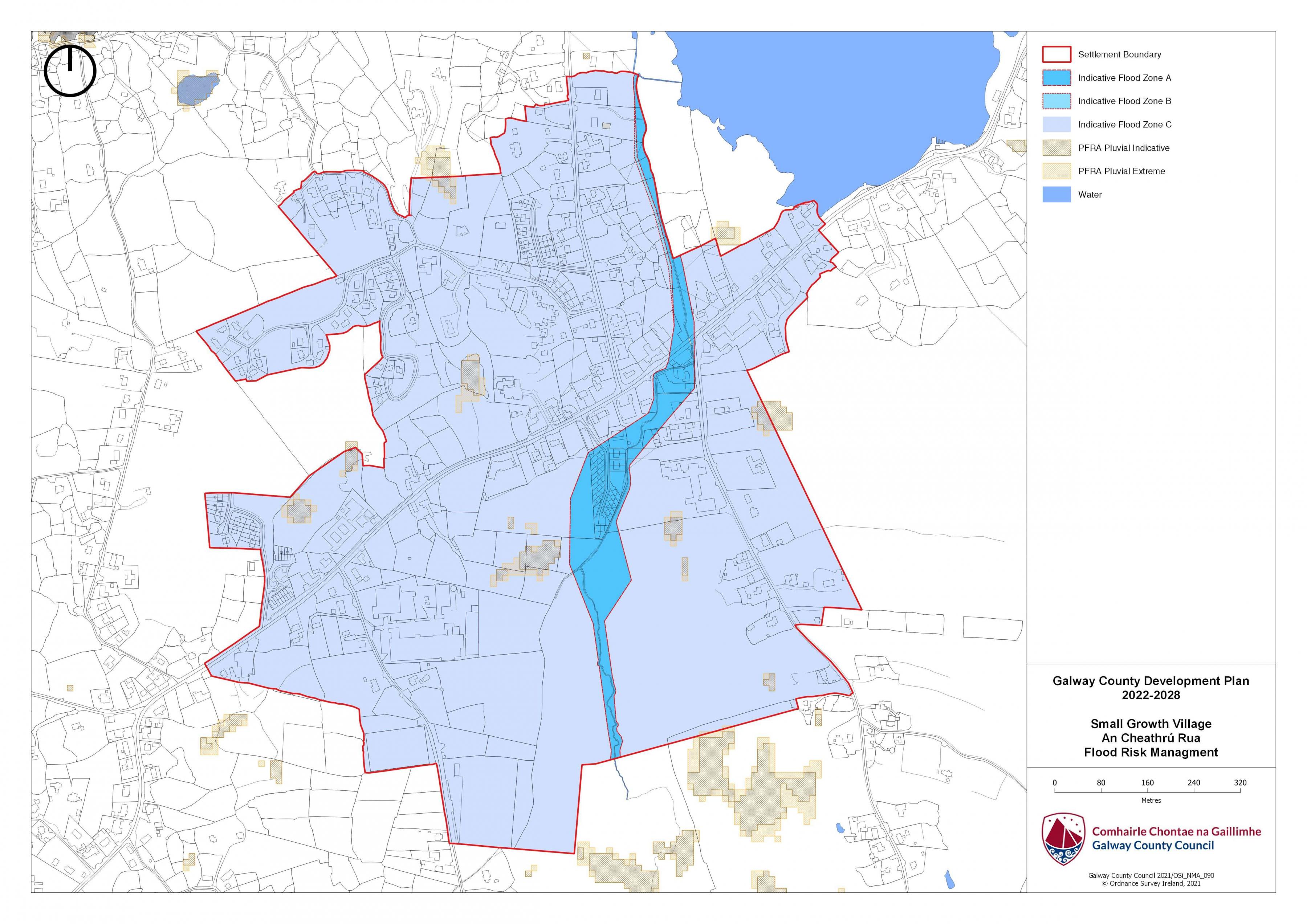
11.5 Flooding
With respect to lands within the village that are liable to flood risk, the Council will require any proposed developments to comply with ‘The Planning System and Flood Risk Management Guidelines for Planning Authorities (DEHLG, 2009) and Circular PL2/2014 and any amendment thereof. The Council, having regard to the nature and scope of development, may require the submission of Flood Risk Assessments, as appropriate, to assess the suitability of development proposals. There is a flood map identified for An Cheathrú Rua and is in accordance with the guidelines and circular referenced above.
|
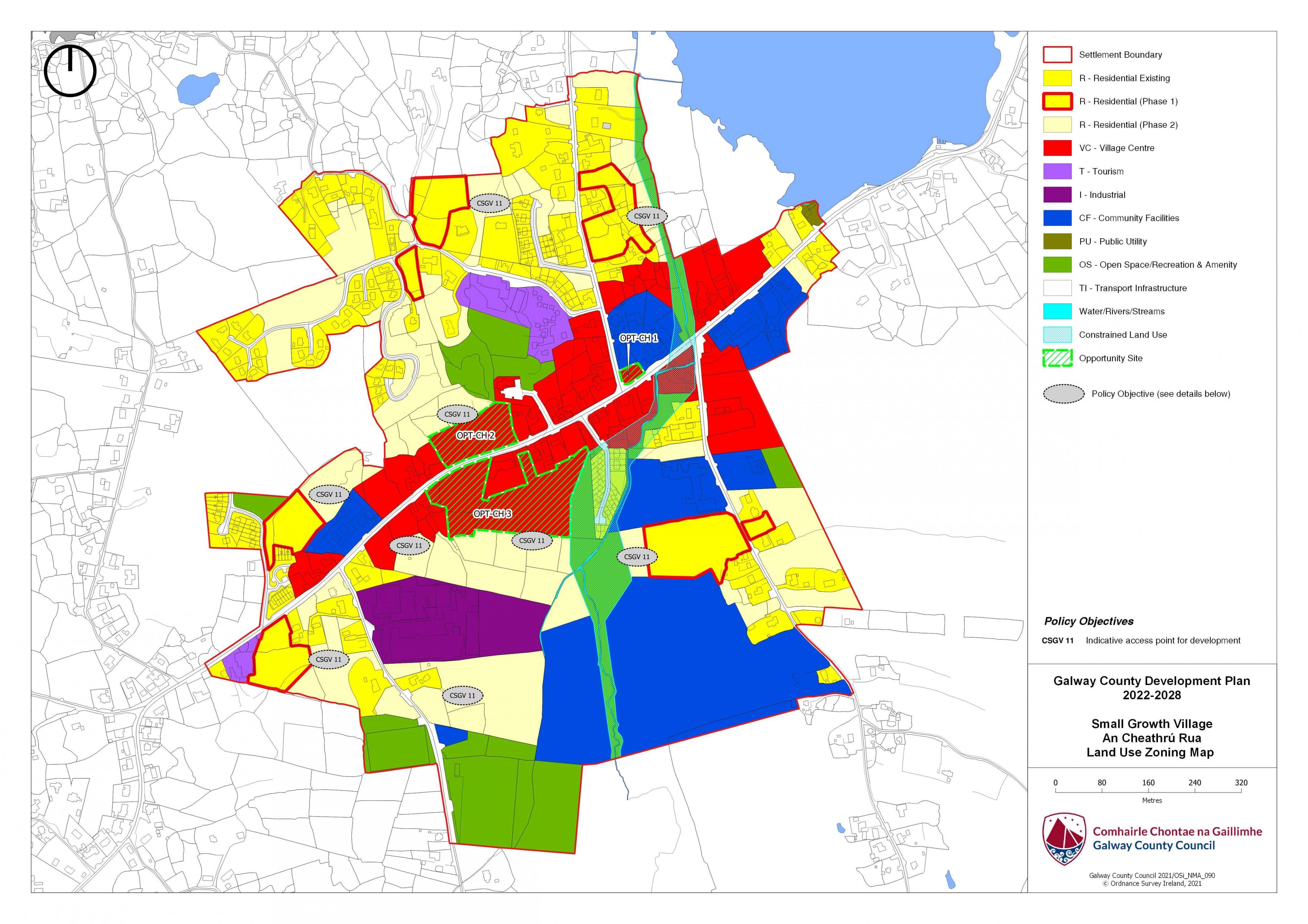
Land Use Zoning Policy Objectives for An Cheathrú Rua (Cheathrú Rua Small Growth Village-CSGV) |
|
CSGV 1 Sustainable Village Centre Promote the development of An Cheathrú Rua village, as an intensive, high quality, well landscaped, human-scaled and accessible environment, with an appropriate mix of uses, including residential, commercial, service, tourism, enterprise, public and community uses as appropriate, that provide a range of retail services, facilities and amenities to the local community and visitors to the villages. The village centre and associated main street shall remain the primary focus for retail and service activity within these plan areas. CSGV 2 Sustainable Residential Communities Promote the development of appropriate and serviced lands to provide for high quality, well laid out and well landscaped sustainable residential communities with an appropriate mix of housing types and densities, together with complementary land uses such as community facilities, local services and public transport facilities, to serve the residential population of An Cheathrú Rua settlement plan. Protect existing residential amenities and facilitate compatible and appropriately designed new infill development, in accordance with the proper planning and sustainable development of the plan area. CSGV 3 Language Enurement Clause A Language Enurement Clause will be applied on a portion of residential units in development of two or more units in An Cheathrú Rua. The proportion of homes to which a language enurement clause will be a minimum of 80% or to the proportion of persons using the Irish Language on a daily basis, in accordance with the latest published Census returns, whichever is greater. CSGV 4 Community Facilities Promote the development of community facilities on suitable lands/sites, in An Cheathrú Rua with a high level of access to the local community, including educational, community, civic, public, institutional, recreational, cultural and other complementary uses, as appropriate. CSGV 5 Local Development and Services To encourage and support the development of local facilities and services to meet the needs of the local community. CSGV 6 Tourism Promote An Cheathrú Rua as a premier tourist destination in its own right and as tourism hubs for the Gaeltacht, offering a high quality, rich and diverse experience to all visitors. CSGV 7 Small Scale Enterprises To encourage the provision of commercial and employment development within the village and in particular the provision of opportunities for small scale start up enterprises. CSGV 8 Streetscape Enhancement Works To seek to facilitate the preparation of a public realm plan that will inform streetscape enhancement works subject to resources being available. CSGV 9 Expansion of Public Infrastructure To Support the expansion of public infrastructure within the village as required. CSGV 10 Signage Promote the Irish language in accordance with the Local Authority's Sceim Teanga. Any external signage that will be erected on buildings and on lands in An Cheathrú Rua shall be in Irish only. CSGV 11 Indicative Access points for Development. Reserve access points to developable lands/ backland areas as indicated on Land Use Zoning map for An Cheathrú Rua. CSGV 12 Opportunity Sites (OPT) To promote and encourage the appropriate re-development of the opportunity sites identified below which will contribute to the vitality and character of An Cheathrú Rua. |
|
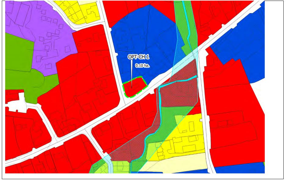
OPT-CH 1 Site An Cheathrú Rua Brief Description: Site located in the centre of the village and contains a derelict cottage. Area: The site area measures circa 0.10 hectares. Zoning: The site is zoned Village Centre. Current land-Use: Existing Low Density Residential. Opportunity: To provide for a mix of uses capable of accommodating village centre/ residential development. The overall development proposal for the site shall include a detailed design brief and landscaping plan taking into account the prominent location of the subject site within the village. |
|
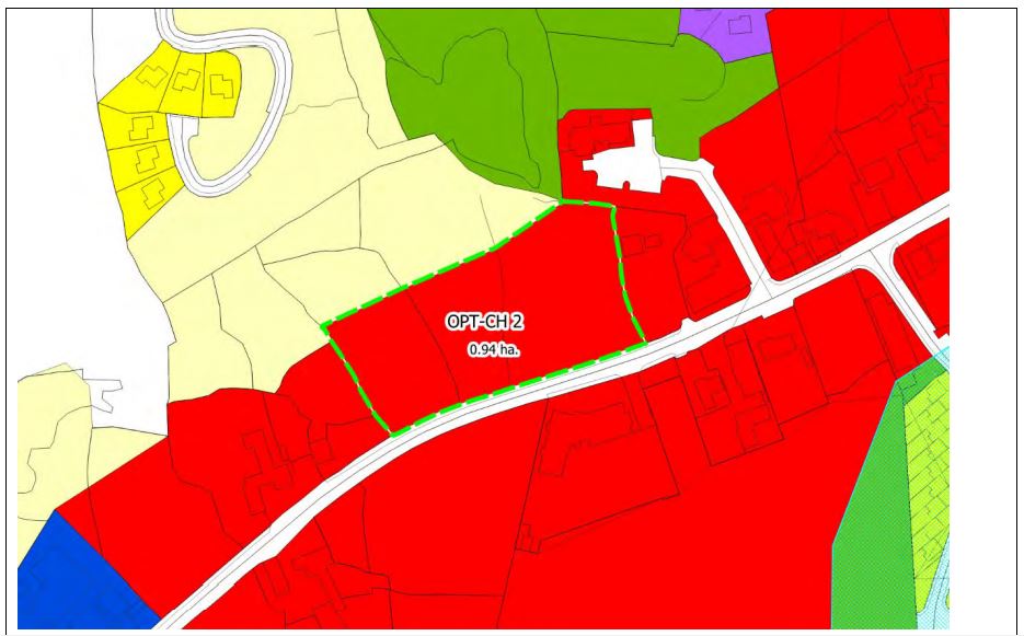
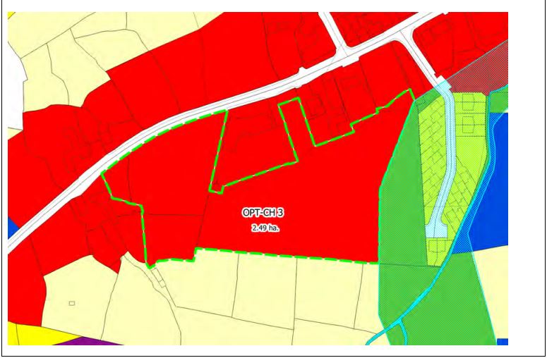
OPT-CH2 Site An Cheathrú Rua Brief Description: This site comprises a vacant green field to the north of the village centre zoning. Area: Opportunity site No.2 measures 1.09 ha. Opportunity site No.3 measures 2.49ha. Zoning: The sites are zoned Village Centre. Current land-Use: Vacant green field sites. Opportunity: To provide for a mix of uses capable of accommodating village centre/ residential development. These are key sites within An Cheathrú Rua and any development proposals should reflect an innovative, high quality building design and appropriate layouts taking into account the location and setting of the subject proposal for the site shall include a detailed design brief and landscaping plan taking into account the prominent location of the subject site within the village.
|
An Cheathrú Rua Land Use Zoning Map
An Cheathrú Rua Flood Risk Management Map
Contents
References
Observations
Observations