Introduction
VHA Architects on behalf of Hyman Properties wish to lodge this submission relating to section 12.1 An Spideal Small Growth Village of the Draft County...
12.1 An Spidéal Small Growth Village
Closed20 May, 2021, 09:00 - 30 Jul, 2021, 16:30
12.2 Village Context
Located 18km west of Galway City in the Conamara Gaeltacht, an Spidéal straddles the R336, it is bound to the north by a rugged landscape of blanket bog overlying granite bedrock and to the south by Galway Bay. The R336 forms the Main Street and links the City to Leenane in the north west of Conamara. The village is also served by a local road which connects it directly to Maigh Cuilinn and the N59 national secondary route.
12.3 Sustainable Communities
12.3.1 Housing
In the case of An Spidéal, this village plan will promote a mix of house types and sizes within the village. The existing housing stock within An Spidéal village comprises a mix of upper floor residential accommodation, with a range of two storey detached and semi-detached dwelling houses along the main street.
Outside the village core, housing developments vary in size and style, comprising a mix of large detached properties and smaller semi-detached and terraced properties that have been built to a higher density.
The settlement would benefit from some regeneration of and re-use of existing properties within the village core. New developments should be well integrated with the existing village and allow for easy and safe access to the centre and main facilities by foot and bicycle. Development which utilises brownfield sites should be prioritised, and all development should be sympathetic to the character of the area. It is also important that the rural character, heritage and natural amenities of the village are maintained, enhanced and not compromised.
12.3.2 Education
Coláiste Chonnacht which is outside of the village boundary is the most significant location for the community’s recreation and amenity activities and it is also used as a summer college for students to learn the Irish language. Scoil Náisiúnta Éinne is the co-educational primary school and is located to the north of the main street within the village centre. The local secondary school Coláiste Chroí Mhuire gan Smál is also a co-educational school.
12.3.3 Community Facilities
There are two working harbours in the village, the tSean Chéibh and an Chéibh Nua and two popular public beaches, which are south-facing beaches Trá na mBan and Trá na Ceibhe which are located on Galway Bay and connected by a scenic walking / cycling path.
Tra na mBan is by the roadside east of the village with a short promenade, while Trá na Ceibhe is sheltered behind the pier, and is reached by car along a narrow road to the west of the village. The rocks behind the pier, and the pier itself, are used for shore angling when the mackerel shoals are in. An opportunity site for a playground has been identified in this plan which would be an asset to the area for both locals and visitors alike.
12.3.4 Environment and Heritage
The eclectic style of the Catholic church, dated 1904 with its Romanesque revival elements, is the work of William A. Scott, one of the leading Arts and Crafts designers of his time. He was also responsible for the loggias which include in their design the sculptural works of Michael Shorthall of Loughrea: carved capitals, corbels and a date-stone depicting animals, foliage and sporting activities.
The L –shaped plan convent dated 1923 forms a key part of the village streetscape. The library is housed in a former school built in 1952 which continues to contribute to the character of the village of An Spideal.
12.3.5 Village Centre, Business & Enterprise
Buildings lining the Main Street vary in style, size and age with the predominant use at ground floor level being commercial. Other uses along this street include Scoil Náisiúnta Éinne , Coláiste Chroí Mhuire gan Smál, the Library and Coláiste an Linbh Íosa. The village has developed beside two neighbouring harbours reflecting the importance of the sea to the coastal community both as a generator of local employment and as a recreational amenity.
The village centre at the crossroads of the R336 and the Maigh Cuilinn Road, contains a good range of retail and commercial services with some residential mix. The eastern edge of the village gradually merges with the almost continuous strip of single rural houses facing southwards and seawards. The eastern edge of the village is more clearly defined by An Spidéal Demesne and the Owenboliska River. There are a number of opportunity sites identified in An Spidéal and are further outlined in policy objective SSGV 12 Opportunity Sites.
12.3.6 Tourism
The coastal location of the village, the local craft village, its unique culture and the proximity of the village to Galway City makes it an attractive tourism location as evidenced by the increase in numbers of summer visitors. Although well within the sphere of influence of the city, An Spidéal retains its own identity and performs an important role as a gateway to the Conamara Gaeltacht and as a local service centre. Set in the landscape typical of the Conamara terrain, the location of An Spidéal Demesne on the western side of the village, containing Spidéal House and associated woodland, provides an important environmental and visual asset to the village.
The village economy is unique, due to the mixture of services that sustains the village and also the wider rural hinterland. It contains a number of small-scale retail shops, public houses, food outlets, offices, a bank and some community service buildings. Ceardlann, Spiddal Craft and Design Studios are located at the entrance to the village of An Spidéal, just beside the beach, overlooking Galway Bay, Cliffs of Moher and Oileáin Árainn. There are several craft workers designing and creating works ranging from stained and fused glass, basket making, photography, pottery, mixed media artist, vintage clothing, painting, weaving, and T-shirt printing. The crafts and locally designed products are popular with both national and international tourists.
12.4 Services and Infrastructure
12.4.1 Water Supply
Public water supply available. The village is served by a public water supply. All lands identified for development potential are served by public water supply.
12.4.2 Waste Water
The village is served by a municipal wastewater treatment system and there is capacity within the network to accommodate development that is envisaged to take place.
12.4.3 Transportation and Movement
The village of An Spidéal is well connected with the existing network of footpaths. They provide safe pedestrian connection in and around the village. Bus Éireann provides daily return services into Galway City with private bus companies providing return transport between the hinterland and the village on a weekly basis.
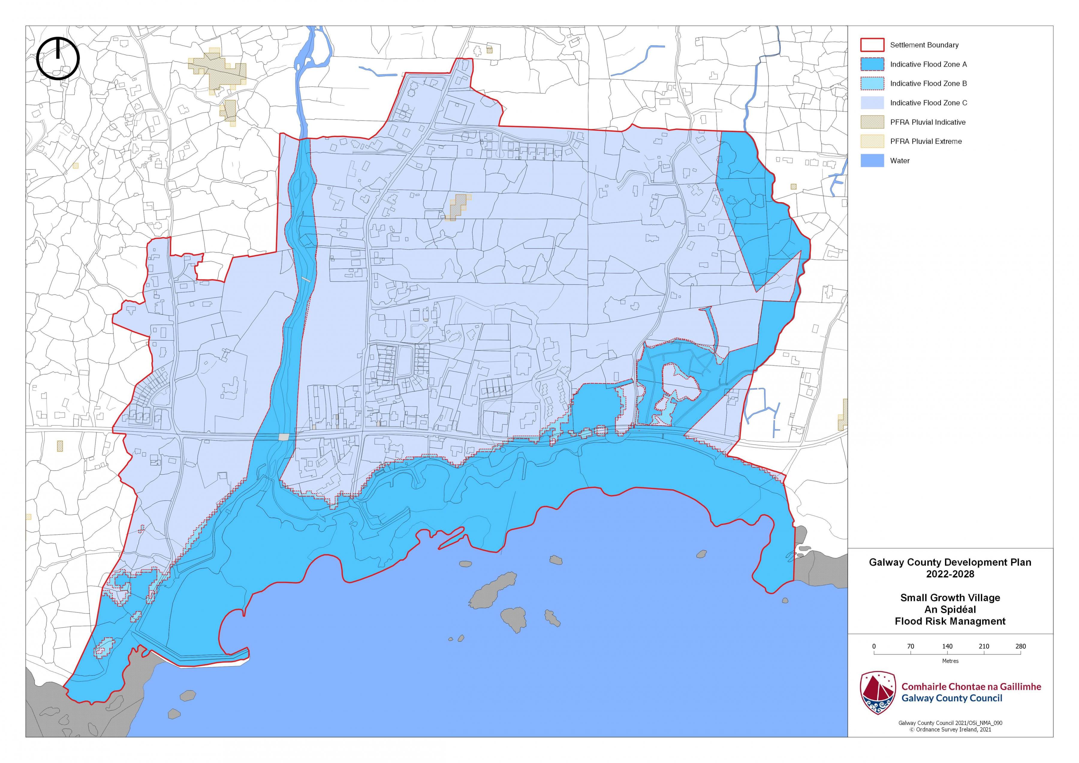
12.5 Flooding
With respect to lands within the village that are liable to flood risk, the Council will require any proposed developments to comply with ‘The Planning System and Flood Risk Management Guidelines for Planning Authorities (DEHLG, 2009) and Circular PL2/2014 and any amendment thereof. The Council, having regard to the nature and scope of development, may require the submission of Flood Risk Assessments, as appropriate, to assess the suitability of development proposals. There is a flood map identified for An Spidéal and is in accordance with the guidelines and circular referenced above
|
Land Use Zoning Policy Objectives for An Spidéal (Spidéal Small Growth Village) |
|
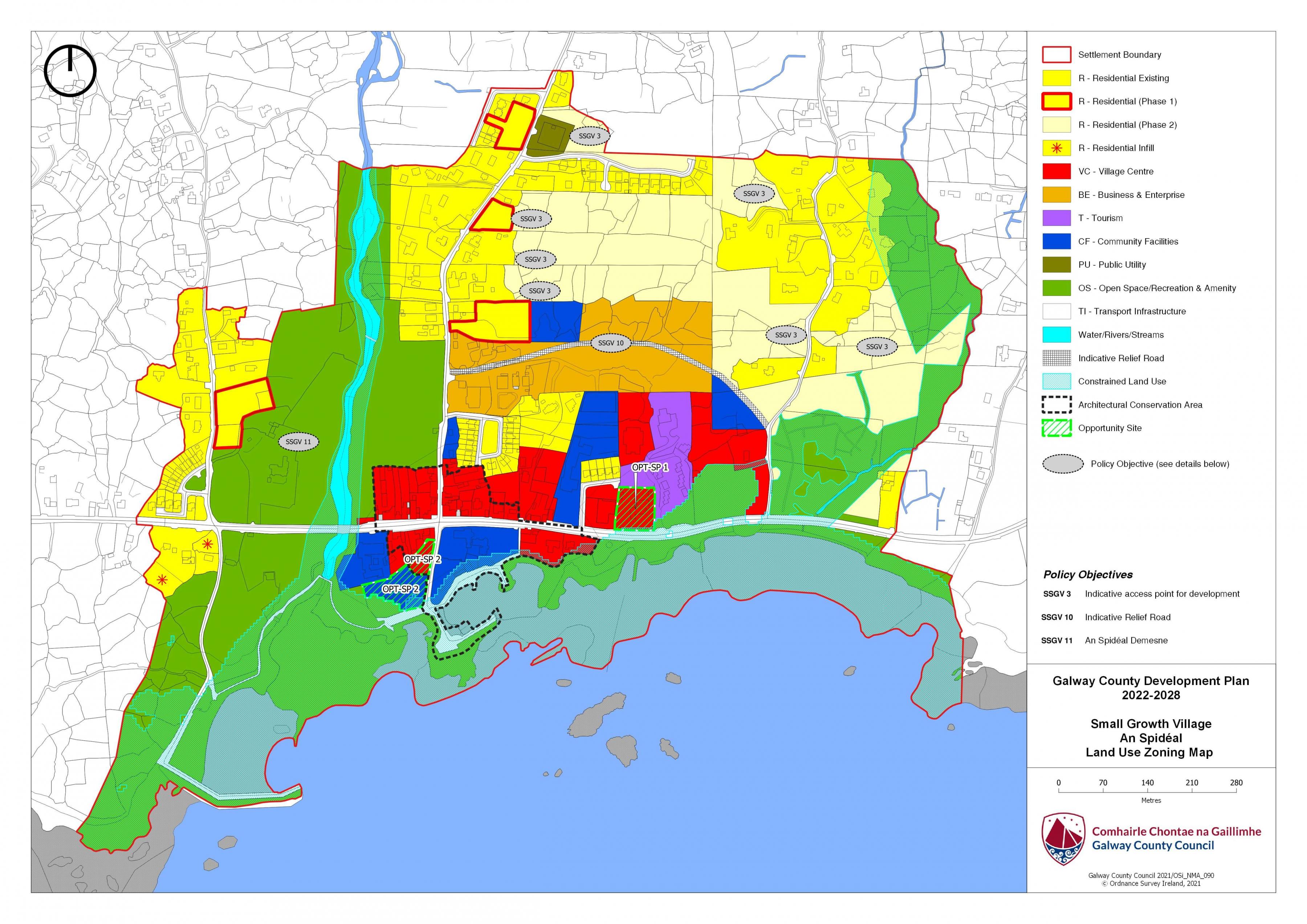
SSGV 1 Sustainable Village Centre Promote the development of An Spidéal village, as an intensive, high quality, well landscaped, human-scaled and accessible environments, with an appropriate mix of uses, including residential, commercial, service, tourism, enterprise, public and community uses as appropriate, that provide a range of retail services, facilities and amenities to the local community and visitors to the villages. The village centre and associated main streets shall remain the primary focus for retail and service activity within these plan areas. SSGV 2 Sustainable Residential Development Promote the development of appropriate and serviced lands to provide for high quality, well laid out and well landscaped sustainable residential communities with an appropriate mix of housing types and densities, together with complementary land uses such as community facilities, local services and public transport facilities, to serve the residential population of An Spidéal. Protect existing residential amenities and facilitate compatible and appropriately designed new infill development, in accordance with the proper planning and sustainable development of the plan areas. SSGV 3 Indicative Access points for Development. Reserve access points to developable lands/backland areas as indicated on Land Use Zoning maps for An Spidéal. SSGV 4 Language Enurement Clause A Language Enurement Clause will be applied on a portion of residential units in development of two or more units in An Spidéal. The proportion of homes to which a language enurement clause will be a minimum of 80% or to the proportion of persons using the Irish Language on a daily basis, in accordance with the latest published Census, whichever is greater. SSGV 5 Community Facilities Promote the development of community facilities on suitable lands/sites, in An Spidéal with a high level of access to the local community, including educational, community, civic, public, institutional, recreational, cultural and other complementary uses, as appropriate. SSGV 6 Local Development and Services To encourage and support the development of local facilities and services to meet the needs of the local community. SSGV 7 Tourism Promote An Spidéal as a premier tourist destination in its own right and as a tourism hub for the Gaeltacht, offering a high quality, rich and diverse experience to all visitors. SSGV 8 Small Scale Enterprises To encourage the provision of commercial and employment development within the village and in particular the provision of opportunities for small scale start up enterprises. SSGV 9 Public Utility Infrastructure Facilitate the provision and maintenance of essential public utility infrastructure, together with necessary ancillary facilities and uses as appropriate within An Spidéal settlement plan area. SSGV 10 Transport Infrastructure Facilitate the provision and maintenance of essential transportation infrastructure. This shall include the reservation of lands within An Spidéal settlement plan areas to facilitate public roads, footpaths, cycleways, bus stops and landscaping, together with any necessary associated works, as appropriate. Any indicative roads be subject to needs assessment and detailed corridor and route selection processes taking into account, inter alia, environmental constraints and opportunities. SSGV 11 Action Area Plan for Spidéal Demesne It is a policy objective of Galway County Council to require that an Action Area Plan is prepared for any development of An Spidéal Demesne taking into account the environmental sensitivities of the area and the reflection of the unique setting of these lands. SSGV 12 Opportunity Sites To promote and encourage the appropriate re-development of the opportunity sites identified which will contribute to the vitality and character of An Spidéal. |
|
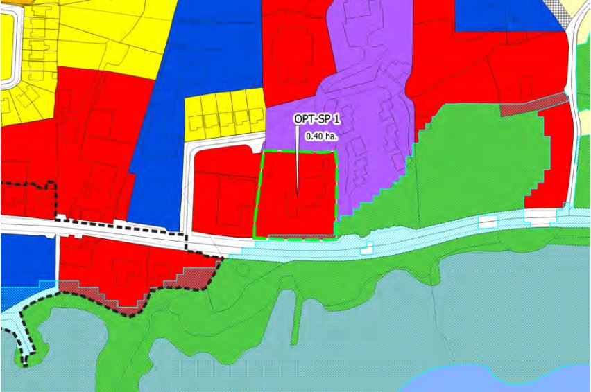
OPT-SP 1 Opportunity Site 1 in An Spidéal Thatch Building on approach into An Spidéal Brief Description: Area: Opportunity site No.4 measures 0.40HA Zoning: The site is zoned Village Centre. Current land-Use: Vacant brownfield site Opportunity: To provide for a mix of uses capable of accommodating retail and or commercial development. The development of the Southern half of the site should reflect its prominent location on the approach into An Spidéal. The overall development proposal for the site shall include a detailed landscaping plan and take into account the prominent location of the subject site at the edge of the village. Innovative, high quality building design and appropriate layouts taking into account the location and setting of the subject lands.
|
|
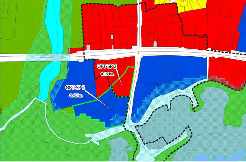
OPT -SP2 An Spidéal Brief Description: Area: The Opportunity Site SP 2 measures 0.14 ha and Opportunity Site SP 2 measures 0.42ha Zoning: The lands are zoned Village Centre and Community Facilities Current land-Use: There is an existing building on part of lands currently operated by the HSE and the remaining lands brownfield. Opportunity: It is considered that a number of community uses including a playground/ a ‘Multi-Use Games Area’ would be appropriate at this key location. Proposals for these lands shall consider the site location/context and the nearby harbour facility in the in terms of design and concept.
|
An Spidéal Land Use Zoning Map
An Spidéal Flood Risk Management Map
Contents
References
Observations
Observations
It is submitted that lands in Baile Ard, at the northern fringe of the proposed village boundary be included within the village boundary and designated Residential 2, on the basis of established...