Maps attached
14.1 Dunmore Small Growth Village
Closed20 May, 2021, 09:00 - 30 Jul, 2021, 16:30
14.2 Village Context
Dunmore is located 50KM north-east of Galway City and 15KM north-east of Tuam town. Dunmore’s settlement pattern has developed over time, on the banks of the Sinking River and at the intersection of the N83 national secondary road with the R328 and R360 regional roads.
The main streets in the Village extend from a central market square. The commercial element of the Village centre is mostly confined to the north and the east of the square. A limited number of local convenience type services exist within the village. The buildings within the village centre range in height up to a maximum of three storeys.
14.3 Sustainable Communities
14.3.1 Housing
There is a large amount of housing stock within the plan area of Dunmore and within the village core. In recent years a number of vacant properties have been converted for residential use within the village core. The more traditional housing stock in Dunmore comprises a good variety of styles and sizes including larger detached properties set within large plots; semi-detached properties and higher density terraced style suburban type housing.
Dunmore has had the benefit of new housing developments which are located within the village envelope, for example Barrack Square is located to the east of the village core, Friars Walk is located to the north-east of the village and Abbeylands is situated to the north of the village. This village plan seeks to ensure sustainable settlement patterns, within the plan area that are well connected to the village centre.
Continued renewal of properties within the Village Core would be desirable and a high standard of design for infill housing development and new or replacement shop-fronts should be in keeping with the overall character of the existing attractive buildings in the village core.
There is scope for development within Dunmore, however, it is important that the village’s rural character, architectural heritage and its other heritage and natural amenities are maintained, enhanced and not compromised.
14.3.2 Education
Scoil Nioclás Naofa is the local primary co-educational school and Dunmore Community School, is the co-educational secondary school.
14.3.3 Community Facilities
Dunmore is serviced with a good range of local services, which include a GAA facility (Dunmore MacHales); separate soccer pitches located on the Fairgreen adjacent to the Augustinian Abbey and a rugby pitches. There is also a nine-hole golf course located to the south of the village, which attracts golf enthusiasts to the area. Dunmore playground is also located within the village and is within walking distances from surrounding neighbourhoods.
14.3.4 Environment and Heritage
Dunmore derives its name from Dún Mór, the big fort. The original fort was a stronghold of the O' Connor Kings of Connacht, later dispossessed by the Norman de Berminghams.
The town has a rich built heritage with Dunmore Castle on the outskirts at Castlefarm which is thought to date from the middle of the thirteenth century and the Augustinian Abbey (founded in 1425) in the townland of Abbeyland South is part of the historic town (GA017-002) of Dunmore and is an National Monument in the ownership of the state.
The village lies in an area of gently rolling countryside. The Sinking River flows through Dunmore and there is an attractive walkway along the river in the town, which is a popular local amenity. The Sinking River is part of the Corrib system and is designated as a Special Area of Conservation (SAC) as part of the Lough Corrib SAC. The Slieve Bog Natural Heritage Area is a few kilometres east of the town.
Dunmore benefits from a river walk by Dunmore Bridge and a Market Square, which provide areas that are used as passive open space. The largest bank of open space is located to the south of the existing Friars Walk housing development. However, the area of land designated as open space has not been optimised to its full potential. Further areas of open space may be designated along the river corridor.
The core area has been designated an Architectural Conservation Area. The rich archaeological heritage of the area is protected by a Zone of archaeological potential centered on the extant 15th century Augustinian Abbey which incorporates a 19th century church. Its ecclesiastical importance is also to be seen in the enclosed late medieval graveyard of St Nicholas’ Abbey in Abbeyland North .
The Bank of Ireland building, though typical in detailing of a late Victorian bank building, is unusually single storey. It is enhanced by the attention to detail seen in the elaborately moulded entrance porch and timber roof brackets and is stylistically unique in the Village. Built over one hundred years ago, it continues to provide financial services to the local community and is a focal point of Dunmore.
14.3.5 Village Centre and Business & Enterprise
Dunmore provides a limited amount of local employment and services to the people of the village and the wider hinterland. The plan will seek to support the development, vitality and vibrancy of the village.
The commercial core of Dunmore is characterised by three storey buildings which reduce to two storey and single storey dwelling houses on the edge of the commercial centre. The Village is served by a large food retailer which is located on the eastern side of the N83.There are numerous retail units, post office and veterinary clinic's in the village. As outlined above there are several buildings that are currently vacant/disused.
The plan will support though the provision of a policy objective, the re-development and re-use of vacant buildings. The planning authority will also encourage regeneration within the Village throughout design and encouraging the use of existing vacant building stock.
Within the village core the aim is to bring the vacant and unused buildings within this area into productive use. The is only limited capacity for small residential schemes or self-built opportunities within the core. However, there are opportunities within the settlement for the redevelopment of existing underutilised properties and derelict dwellings to the east of the village. Development proposals locating within the village core will be supported and facilitated where appropriate especially Living Over the Shop Opportunities in the village core.
14.4 Services and Infrastructure
14.4.1 Water Supply
There is a public water supply available. All lands identified for development potential are served by public water supply.
14.4.2 Waste Water
The village is served by a municipal wastewater treatment system. There is capacity within the network to accommodate development that is envisaged to take place.
14.4.3 Transportation and Movement
The N83 is the National Primary Road between Tuam and Ballyhaunis, which transverses through Dunmore. Bus Éireann provides residents with a means of public transport to Galway City which includes a stop at GMIT. A private bus company provides connection between Dunmore and Tuam town centre. The bus stop is within the village centre and as such is accessible to those living in and around the village.
There has been a recent public consultation regarding the road improvement works needed within the village of Dunmore to facilitate ease of access. This is currently at the design stage of the process.
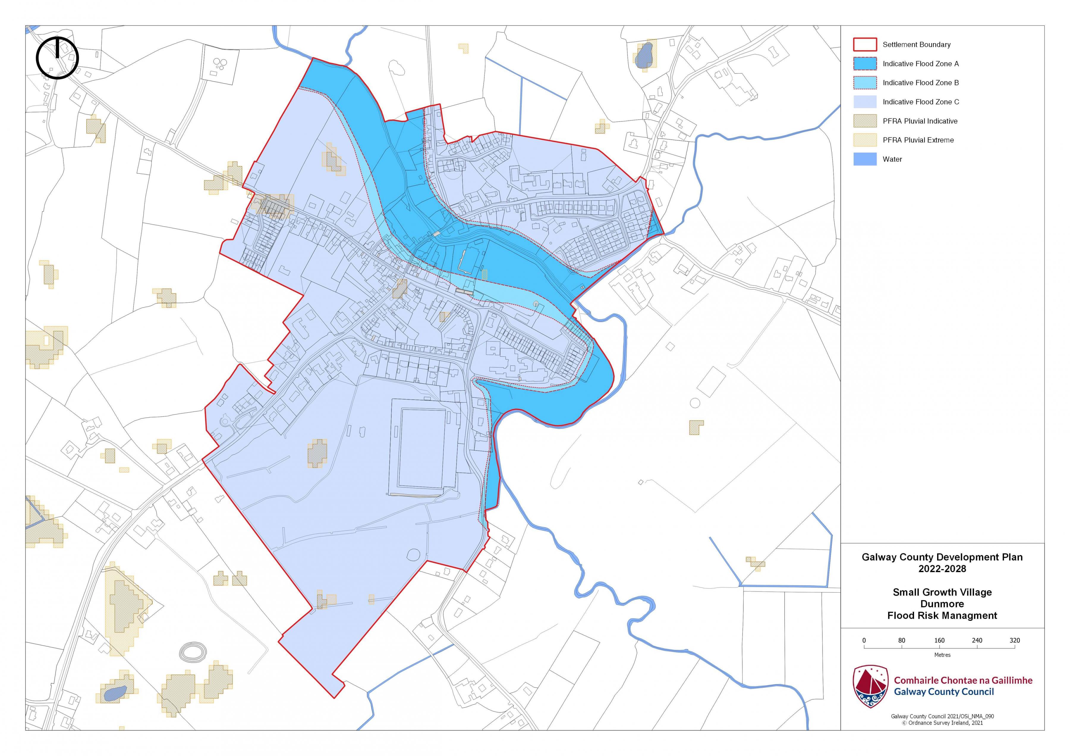
14.5 Flooding
With respect to lands within the village that are liable to flood risk, the Council will require any proposed developments to comply with ‘The Planning System and Flood Risk Management Guidelines for Planning Authorities (DEHLG, 2009) and Circular PL2/2014 and any amendment thereof. The Council, having regard to the nature and scope of development, may require the submission of Flood Risk Assessments, as appropriate, to assess the suitability of development proposals. There is a flood map identified for Dunmore and is in accordance with the guidelines and circular referenced above.
|
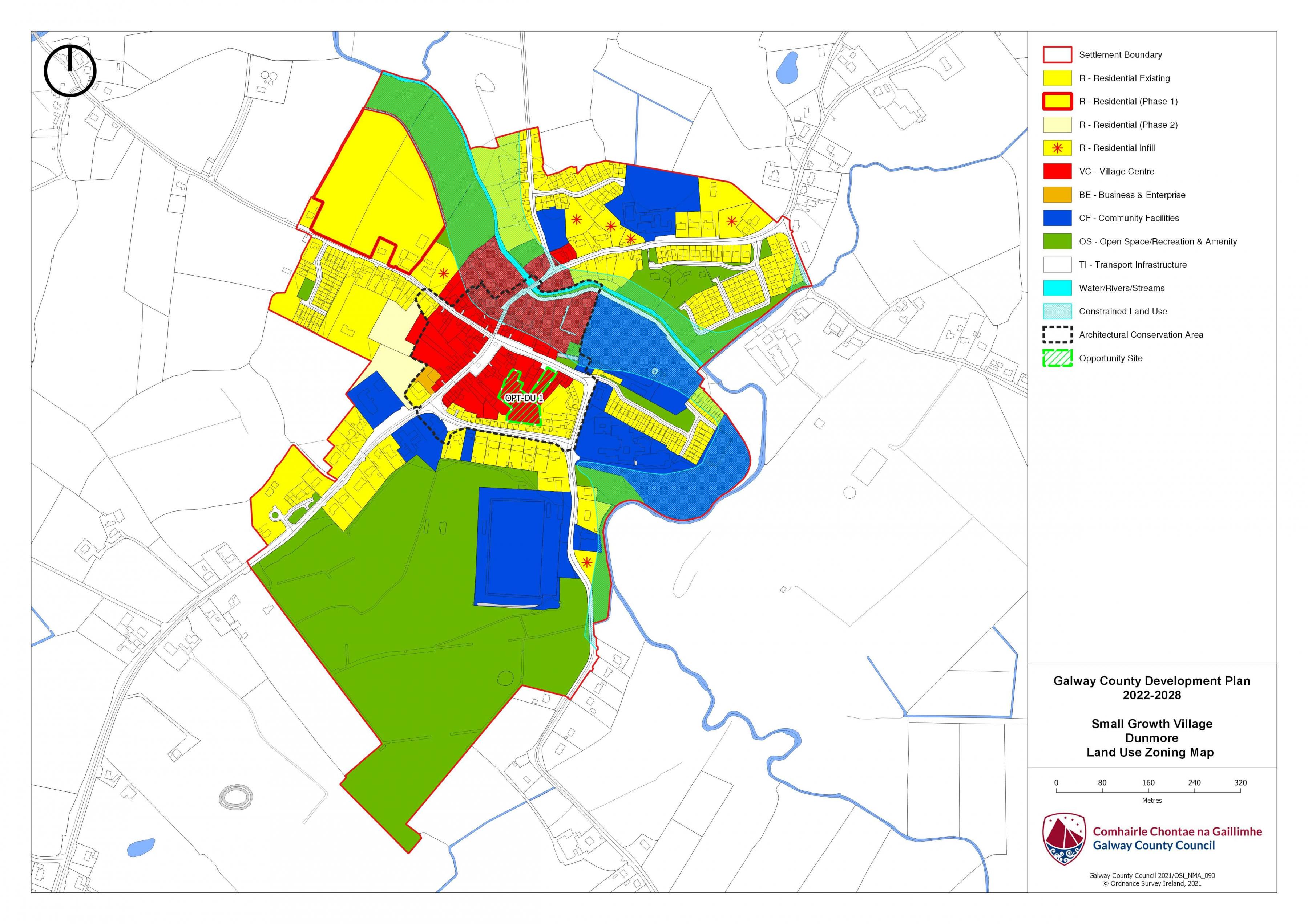
Land Use Zoning Policy Objectives for Dunmore (Dunmore Small Growth Village) |
|
DSGV 1 Sustainable Village Centre Promote the development of Dunmore village, as an intensive, high quality, well landscaped, human-scaled and accessible environment, with an appropriate mix of uses, including residential, commercial, service, tourism, enterprise, public and community uses as appropriate, that provide a range of retail services, facilities and amenities to the local community and visitors to the villages. The village centre and associated main street shall remain the primary focus for retail and service activity within these plan areas. DSGV 2 Sustainable Residential Communities Promote the development of appropriate and serviced lands to provide for high quality, well laid out and well landscaped sustainable residential communities with an appropriate mix of housing types and densities, together with complementary land uses such as community facilities, local services and public transport facilities, to serve the residential population of Dunmore village. Protect existing residential amenities and facilitate compatible and appropriately designed new infill development, in accordance with the proper planning and sustainable development of the plan area. DSGV 3 Community Facilities Promote the development of community facilities on suitable lands/sites, in Dunmore with a high level of access to the local community, including educational, community, civic, public, institutional, recreational, cultural and other complementary uses, as appropriate. DSGV 4 Local Development and Services To encourage and support the development of local facilities and services to meet the needs of the local community. DSGV 5 Small Scale Enterprises To encourage the provision of commercial and employment development within the village and in particular the provision of opportunities for small scale start up enterprises. DSGV 6 Streetscape Enhancement Works To seek to facilitate the preparation of a public realm plan that will inform streetscape Enhancement works subject to resources being available. DSGV 7 Expansion of Public Infrastructure To Support the expansion of public infrastructure within the village as required. DSGV 8 Opportunity Site To promote and encourage the appropriate re-development of the opportunity site identified which will contribute to the vitality and character of Dunmore. |
|
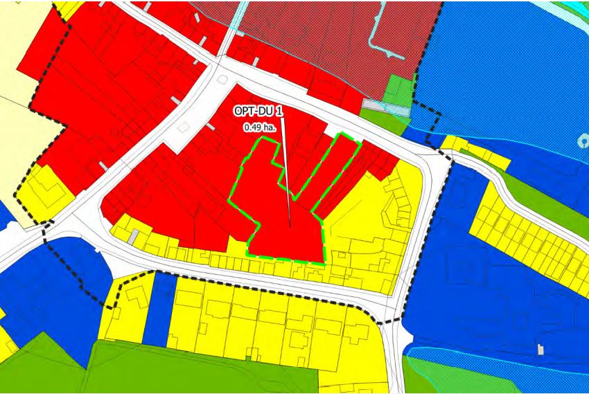
OPT-DU 1 Opportunity Site Dunmore Brief Description: The site is greenfield within the centre of Dunmore village. Area: Opportunity site No. 1 measures 0.49HA Zoning: The site is zoned Village Centre. Current-Land-Use: Vacant greenfield site. Opportunity To provide for a mix of uses capable of accommodating retail and or commercial development. The overall development proposal must address the street frontage where the prominent use of land changes from residential to commercial. Innovative, high quality building design and appropriate layouts taking into account the location and setting of subject lands. A mix of commercial and residential uses or a mews type development may be appropriate here.
|
Dunmore Land Use Zoning Map
Dunmore Flood Risk Management Map
Contents
References
Observations
Observations
Dear Sirs, with reference to the above, I would like to make the following comments, however, they only relate to the area Dunmore/Tuam area.
Galway C C do not appear to look at...