
See map
6.1 Headford Small Growth Town
Closed20 May, 2021, 09:00 - 30 Jul, 2021, 16:30
6.2 Town Context
Headford is located approximately 26km north of Galway City and 20km west of Tuam ensuring ease of access to the wider range of service provision in both of these areas. The town straddles the county boundary with County Mayo and it is strategically located along the National Secondary Road, the N84 which provides good transport links between Galway and Mayo while also acting as the main vehicular gateway to the town.
The landscape, topography and natural features of the area have influenced the pattern and form of development of the Town over the years. The rural character of the surrounding landscape, rich heritage and its proximity to Lough Corrib, provide many amenity opportunities for the Town. The town is situated south of the Black River which is the county boundary with Mayo. It is an angling centre for the eastern shore of Lough Corrib, and Greenfields, some 6.5 km west of the town, is its boating harbour.
6.3 Sustainable Communities
6.3.1 Housing
The centre of Headford is characterised by its cohesive development as a predominantly 19th century commercial market Town, laid out as a planned settlement in relation to the landlord’s mansion, Headford Castle and its demesne.
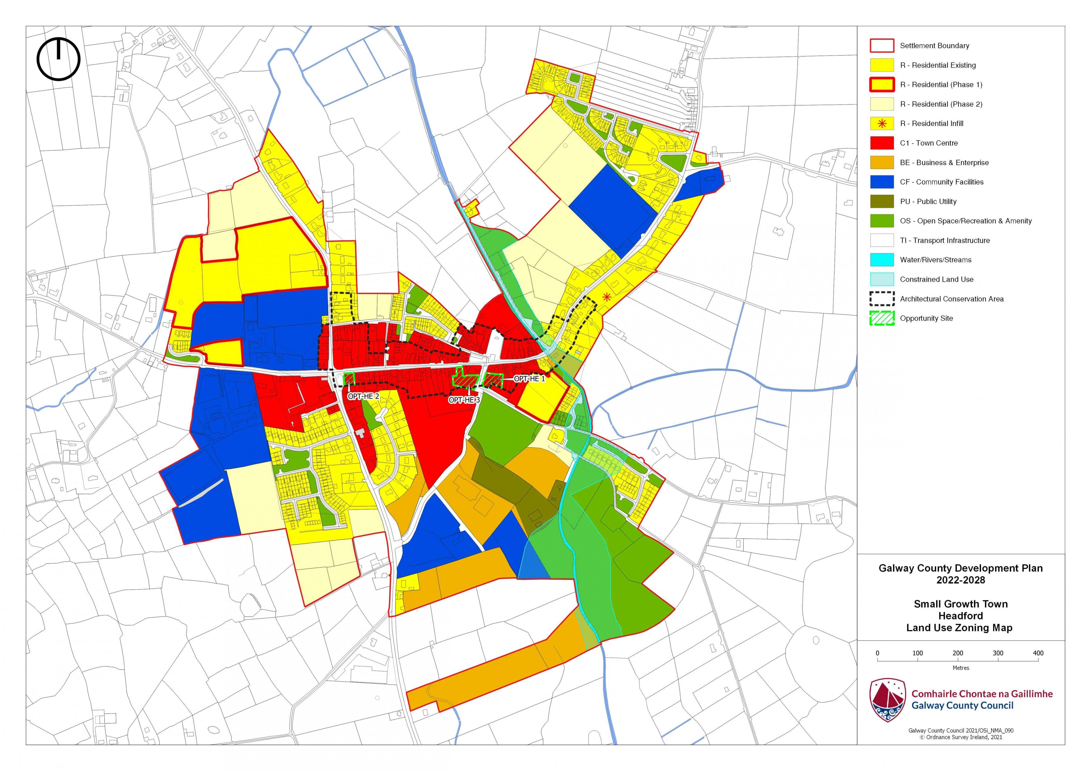
The town core of Headford is high density in layout and has developed in a sustainable manner overtime radiating out to the south and east from the main street. A number of housing estates have development to the south, south-east and north-east of the town core with some infill housing in the town centre and within the development boundary. The existing housing building stock in the town core comprises a mix of traditional housing stock with some infill developments. There are a number of well-established housing estates within the development boundary including Meadow Hill, Castleview, St. George’s, the bungalows along New Street and the infill housing developments off New Street, The Square development and Ashthorn Avenue.
Residential land supply in Headford is located to the north and east of the town centre with smaller plots to the south. There is also significant supply of infill sites zoned for residential use /opportunity sites in the town centre.
6.3.2 Education
In terms of education, Headford has two primary schools, Scoil Breandain Naofa (Boys School), is a Senior boys school comprising of four classes of boys from third to sixth class. Scoil Mhuire na Dea Chomhairle (Girls School) adjoins the boy's school. The Girls school accommodates boys up to second class. Headford has one of the largest secondary schools in the county, with pupils travelling from a wide catchment area for secondary education in the co-educational Presentation Secondary School.
6.3.3. Community Facilities
Headford has some well-developed community and recreation facilities throughout the town including the schools, a library, credit union, a children’s playground, churches and graveyards, medical facilities, Garda station, bank, post office and a number of sport pitch. These facilities are predominantly located to the west of the town.
Social clubs/groups that cater for both young and older persons include the bridge club, Headford Musical Society, Headford Development Association, Moyne Villa FC, Headford GAA, Corrib Rugby Football Club, Sean Chairde Atha Chinn, Solstice Arts Group, Headford Tidy Towns, Headford / Solas Mens Shed and Headford Environment Group.
6.3.4 Environment and Heritage
Headford’s centre runs from St. George’s Square at the eastern end of the Town to St. Mary’s Roman Catholic Church to the west and this area has been the focal point for the Town, playing a pivotal role in the administrative, commercial, cultural, recreational, residential and community functions of the Town. The town is laid out as a planned settlement in relation to the landlord’s mansion, Headford Castle and its demesne. The domestic and commercial buildings themselves are, in most part, of a simple vernacular style, counter pointed by the neoclassical architecture of the public buildings.
The designation of the historic town centre as an Architectural Conservation Area and the associated management of both individual buildings and the public realm in that area will significantly enhance the quality of the local environment within Headford. The principal significance of the designated ACA lies in its development as a predominantly 19th century settlement. There are a number of protected structures located within the Headford Plan area, examples includes St. Mary’s Church and St. John the Baptist Church. Landmark buildings, such as the former Catholic Church in the core of the Town continue to contribute to the urban streetscape.
Headford Demesne is an example of a designed landscape within the plan area. It was part of the estate owned by the St. George family until its dissolution in 1892 by the Land Commission. It contained a manor house, outbuildings, ornamental gardens, parkland and woodland, much of which is lost. The most remarkable features to survive are the high stone walls that surrounded the many gardens and the demesne itself. These are a significant feature in the landscape and contribute to the character of Headford.
Headford also has a rich archaeological heritage, with a number of recorded monuments, providing evidence of early settlement in the area.
The various streams and rivers such as the Headford River and the Annacurta Stream in the plan area function as ecological corridors before they drain into a designated site – Lough Corrib SAC, pNHA & SPA. Trees and hedgerows are also of high local biodiversity value and contribute to ecological connectivity.
6.3.5 Employment and Economic Development
Headford has been designated as a Small Growth Town (SGT) in the Settlement Hierarchy for the County. Headford provides a limited amount of local employment and services to the people of the Town and those within its hinterland and the plan will seek to support the development, vitality and vibrancy of the town.
Due to its proximity to Galway City, Headford serves as an important commuter town but it also has the potential to become increasingly more self-sufficient by the creation of employment opportunities, while still accommodating small scale and start-up businesses.
There is a small local employment base through its retail provision, services and modest industrial/enterprise sectors. Headford has a limited industrial and enterprise base.
The promotion of economic development and employment creation will be appropriately guided to ensure the protection of residential amenities, built and natural heritage, landscape and streetscape, character of the town and the vitality and viability of the Town centre.
6.3.6 Town Centre/Retail
The town centre area remains the primary focus for the location of new retail development, with opportunities to develop this sector in a consolidated and sequential manner. The development of any future retail and non-retail services in the town needs to be carefully planned, designed and managed in order to protect and enhance the town’s unique character while promoting the economic vitality of the town centre and providing a strong base for employment opportunities.
Headford has a mix of both convenience and comparison shopping with a good number of restaurants and bars with ample provision of business and financial services dispersed throughout the identified retail core. The residents to the east and western parts of the town are well served by two supermarkets. The retail core has a significant surplus of vacant retail space within the identified retail core.
A number of opportunity sites have been identified within the Town Centre and outlined in policy objective HSGT 12. Each of the three sites have a distinct quality and character and plays a key role in the sustainable functioning of the overall town and the town centre.
6.3.7 Tourism
Tourism is an important sector in the local area, as a driver of the local economy as well as a mechanism for the preservation and enhancement of local heritage. Headford and its surrounding area have a significant number of tourist attractions focussing on water-based recreation, its natural heritage, it’s archaeological and architectural heritage, while nearby Ross Eirilly forms part of the driving trail of the Ecclesiastical Heritage Sites in East Galway.
The Headford Lace Project won the 2017 Tidy Towns Heritage Award as the judges from the Heritage Council were particularly impressed by the innovative and creative approach taken by the project which began following Headford’s involvement in the Galway 2020 ‘Small Towns Big Ideas’ pilot project.
The tourism aspects of Headford remains largely undeveloped, which also presents a significant opportunity to expand and promote the tourism base of the area, particularly given Headford’s close proximity to Lough Corrib and heritage sites such as nearby Ross Errily.
6.4 Services and Infrastructure
6.4.1 Water Services
Headford receives its water supply from the Tuam Regional Water Supply Scheme which is abstracted from Lough Corrib at Luimnagh. In this regard, public water supply is not a limiting factor for development.
6.4.2 Wastewater Disposal
The town is served by a municipal wastewater treatment system and there is capacity within the network to accommodate development that is envisaged to take place.
6.4.3 Transportation Infrastructure and Movement
Headford is strategically located along the National Secondary Road, the N84 which provides good transport links between Galway and Mayo while also acting as the main vehicular gateway to the Town. The regional roads are also important links to and from the Town. The R334 enters the Town from the north-west and provides good links with Cross and West Galway while the R333 is the western approach road and connects up with the N83 National Road the M17 Motorway west Tuam Town.
Public transport in Headford is limited to bus services, consisting predominantly of local services which play a vital role in connecting Headford to Galway and Headford to Ballinrobe and Ballina.
6.5 Flooding
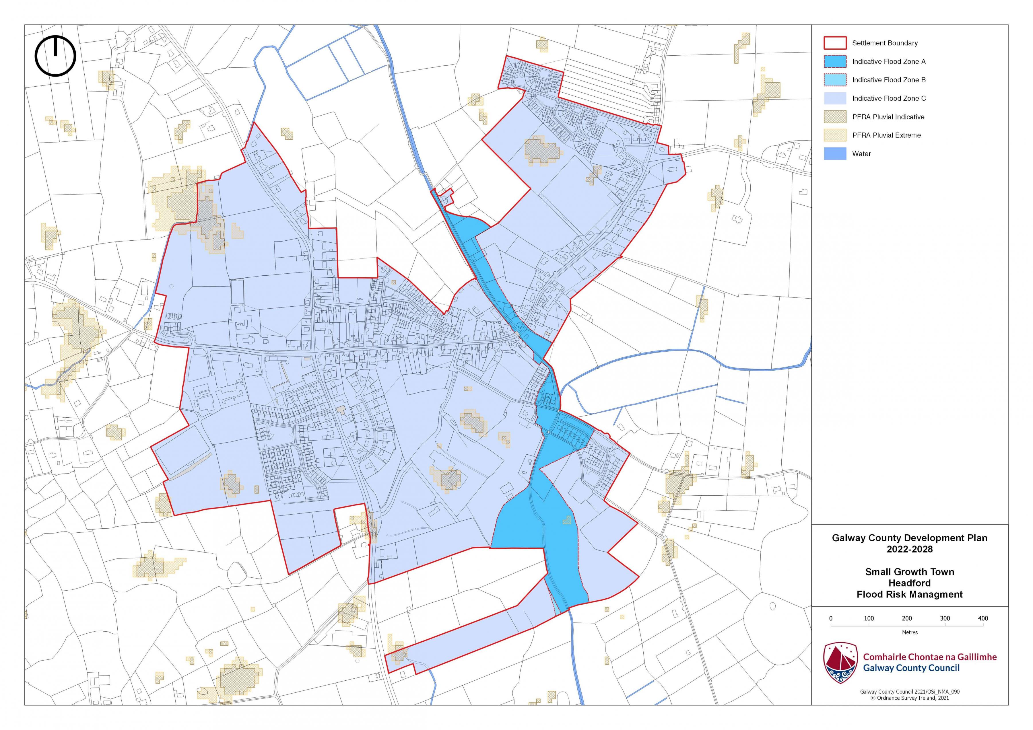
With respect to lands within the village that are liable to flood risk, the Council will require any proposed developments to comply with ‘The Planning System and Flood Risk Management Guidelines for Planning Authorities (DEHLG, 2009) and Circular PL2/2014 and any amendment thereof. The Council, having regard to the nature and scope of development, may require the submission of Flood Risk Assessments, as appropriate, to assess the suitability of development proposals. There is a flood map identified for Headford and it is in accordance with the guidelines and circular referenced above.
|
Land use Zoning Policy Objectives for Headford (Headford Small Growth Town–HSGT) |
|
HSGT 1 Sustainable Town Centre Promote the development of Headford, as an intensive, high quality, well landscaped, human-scaled and accessible environment, with an appropriate mix of uses, including residential, commercial, service, tourism, enterprise, public and community uses as appropriate, that provide a range of retail services, facilities and amenities to the local community and visitors. The Town centre and associated main street shall remain the primary focus for retail and service activity within these plan areas. HSGT 2 Sustainable Residential Communities Promote the development of appropriate and serviced lands to provide for high quality, well laid out and well landscaped sustainable residential communities with an appropriate mix of housing types and densities, together with complementary land uses such as community facilities, local services and public transport facilities, to serve the residential population of Headford settlement plan. Protect existing residential amenities and facilitate compatible and appropriately designed new infill development, in accordance with the proper planning and sustainable development of the plan area. Specifically encourage living over the shop which can contribute to the vitality of the core and extend activity beyond business hours. HSGT 3 Community Facilities and Services Promote the development of community facilities on suitable lands/sites, in Headford with a high level of access to the local community, including educational, community, civic, public, institutional, recreational, cultural and other complementary uses, as appropriate. HSGT 4 Business and Enterprise To facilitate the expansion of business and enterprises uses in the plan area of Headford where appropriate and to facilitate he provision of further local employment opportunities in accordance with the proper planning and development of the area. HSGT 5 Town Centre/Commercial Promote the development of the Town centre as an intensive, well connected, high quality, and accessible environment, with an appropriate mix of uses, that provide a range of retail, services, facilities and amenities to the local community and visitors. The Town centre and associated main streets shall remain the primary focus for retail and service activity within Headford. It is important to ensure a balance of development in the retail core so as to ensure that the main street, High Street is revitalised, vacancies are reduced and an unbalanced retail pull from this area is avoided. HSGT 6 Tourism Development Promote and facilitate the further development of Headford as a sustainable tourist destination for the benefit of the Town and its surrounding areas. HSGT 7 Headford Demesne Protect, conserve and enhance the character of the area of the historic demesne of Headford that lies within the plan boundary through the appropriate management and control of the design, layout and location of new development within or in proximity to same. HSGT 8 Mart Road Action Area Plan Support the co-ordinated expansion of the Town centre southwards from the main street, High Street, towards the Mart Road and require the preparation of an Action Area Plan for the sensitive and appropriate development of this area. The Action Area Plan and any development within this quarter shall demonstrate the following: (a) Provision of adequate public carparking facilities in the vicinity of the Town centre. (b) A co-ordinated vehicular access arrangement, which shall be in consultation and agreement with the Road Design Section of Galway County Council. (c) Maintain vehicular access to this area at the junction of the Mart Road and the Demesne Road and also between the southern side of Main Street and this area. (d) Provide footpath and cycling links to the Town centre. (e) Buildings shall be of a high-quality design and materials, particularly along the road edge providing enclosure and strong frontage. (f) Provision of appropriate landscaping and usable public spaces. (e)Screened car parking. HSGT 9 New Business and Enterprise Quarter Require the preparation of an Action Area Plan for the sensitive and appropriate development of the business and enterprise zoned lands to the south east of the plan area (east of N84). The Action Area Plan and any development within this quarter shall demonstrate the following: (a) Co-ordinated access arrangements, in consultation and agreement with the Road Design Section of Galway County Council, preferably from the Mart Road or existing access serving the pitch and putt/Headford Community Gardens. (b) Provision of footpath and cycling links to the Town centre. (c) Buildings shall be of a high quality design and materials, particularly along the road edge providing enclosure and strong frontage. (d) Provide appropriate landscaping and usable public spaces. ( e ) Screened car parking. HSGT 10 Preparation of a Revised Traffic Management Plan It is a policy objective to revise/implement a Traffic Management Plan for Headford within the life of this plan, which shall include the following; (a) Provisions to address the issues with parking on the main street and the traffic congestion resulting from parking on both sides of the street. (b)Seek to redesign the intersection of the Mart Road and the Demesne Road junction. (c) Facilitate the upgrade of the Mart Road and the local roads L-61281 and L-6128 (Demesne Road) within the plan boundary. Any upgrade shall facilitate public lighting, pedestrian and cycling facilities. (d) Upgrade the junction of the Mart Road and the N84 within the 50kmh speed zone to provide for coordinated access to the Business & Enterprise lands east of the N84. Such access arrangements shall be carried out in consultation and agreement with the Road Design Section of Galway County Council. (e) In order to safeguard the capacity, efficiency and safety of the N84 national route, new accesses on this national route between the 50 and 60kmh zone shall be limited, and in this regard the future development of lands to the east of the N84 shall be required to provide for a coordinated access and traffic management approach, which shall be carried out in consultation and agreement with the Road Design Section of Galway County Council. (f) Facilitate the development of public car parking facilities in town. (g) Reserve access points for future development and for the development and access to backlands so as to ensure adequate vehicular, pedestrian and cycle access to backlands, in order to facilitate efficient development of these lands and to ensure connectivity and accessibility to lands with limited road frontage. (h) Ensure the provision of a northern link road (including pedestrian and cycling facilities) between the R334 and St. George’s Square to facilitate access to residential lands located between these two roads. (i) Seek to provide a southern link to New Street from the proposed northern link road and reserve an access for same. (j) Seek to upgrade the junction of the L-61301 and the N84. (k) Ensure the provision of footpaths & public lighting from the existing residential development along the L-6128-1 (Demesne Road) to the Town centre and the R334 (Regional Road) to the Town centre. Cycling facilities shall also be provided in these locations where feasible. (l) Facilitate traffic calming measures along the Demesne Road (L-6128-1). (m) New development shall be required to ensure that they are satisfactorily connected to the footpath & public lighting network that currently services the town centre. HSGT 11 Public Infrastructure Support and encourage infrastructural development and improvement works that benefit Headfpord as an SGT and the wider Region. HSGT 12 Opportunity Sites To promote and encourage the appropriate re-development of the opportunity sites identified below, which will contribute to the vitality and character of Headford. |
|
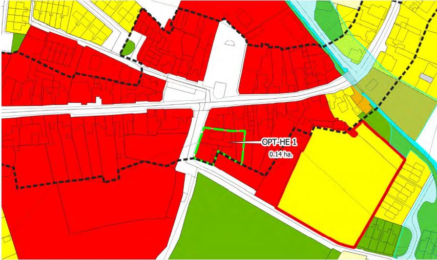
OPT-HE1 Site South of Town Centre and Main Street Headford. Description: This site to the south of Main Street includes some sizeable rear gardens serving the properties, a vacant yard area to the north-eastern part of the site with the fields extending down as far as the Mart Lands. The predominant land use is agriculture. Area: The site area measures circa. 0.14ha hectares. Zoning: The site is zoned Town Centre. Current Land-Use: The predominant land use is agriculture with the fields to the south of the dwellings and gardens currently used for grazing cattle and sloping down towards the Mart Lands and Access Road. Opportunity: To provide for a mix of uses capable of accommodating tourism, residential, commercial or a mixed use development.
|
|
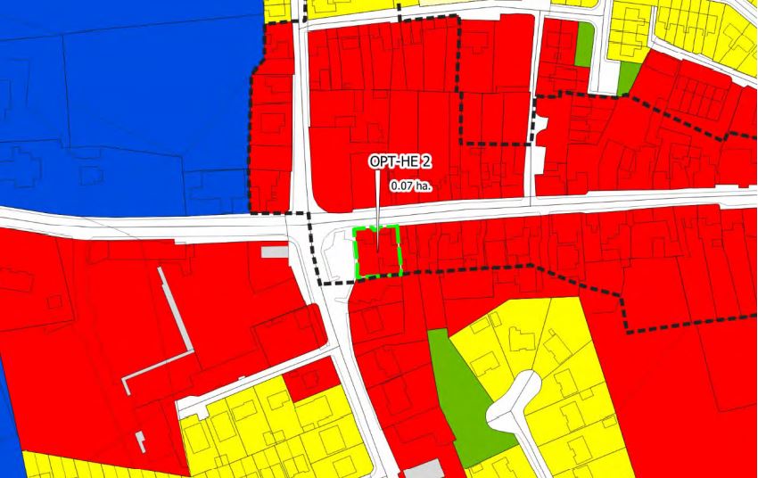
OPT-HE2 Site South - East of Town Centre area off Square. Description: There is a derelict bungalow on the northern part of this site and two modest disused stone buildings/ storage sheds with natural slate on roofs on the southern overgrown part of this site all of which are located within the ACA. The natural stone wall boundary remains intact along the southern site boundary. Area: The site area measures circa 0.07 hectares Zoning: The site is zoned Town Centre. Current Land-Use: Previous use residential with the two modest disused stone buildings used for storage in the past. Opportunity: To provide for a mix of uses capable of accommodating tourism, residential, commercial or a mixed use development.
|
|
OPT-HE3 Site Corner site - High Street & The Square. Description: This plot fronts onto both the Main Street and the Square. It wraps around the large 2-Storey dwelling located on the corner of the site. To the rear and south of the dwelling the plot is vacant with a tall boundary (painted with murals) and there is a derelict single storey building (shop front with door and two windows) to the east of the plot and fronting onto the Main Street. There is a vacant 2-Storey dwelling further west fronting onto the Main Street. Area: The site area measures circa0.21hectares. Zoning: The site is zoned Town Centre. Current Land-Use: Vacant – Previous use residential and possibly retail. Opportunity: To provide for a mix of uses capable of accommodating tourism, residential, commercial or a mixed use development.
|
Headford Land Use Zoning Map
Headford Flood Risk Management Map
Contents
References
Observations
Observations