Please find submission attached
17.1 Moylough Small Growth Village
Closed20 May, 2021, 09:00 - 30 Jul, 2021, 16:30
17.2 Village Context
The village of Moylough is located 52km north-east of Galway City. The N63 approaches the village from a south-westerly direction from Abbeyknockmoy. The village of Moylough is located just 5 km from Mountbellew. The main National route (N63) and the main regional route R364 intersect at Moylough to form a crossroads on which the village is centred. This is a rural compact village, with a strong link with the larger rural village of Mountbellew, not least to avail of the post primary education facilities in Mountbellew as Moylough does not have its own secondary school. While the village of Moylough is small, it retains many of the essential services that other villages do not have. These include a Garda Station, Post Office and community centre.
17.3 Sustainable Communities
17.3.1 Housing
Along with the other settlements of a similar size, this settlement plan will promote a mix of house types and sizes within the village. Within the village of Moylough there is already a variety of house types and sizes. This includes a linear settlement pattern on the approach roads to the village. Typically, these residential units comprise of bungalows and two storey dwelling houses set within large plots. Terraced type properties are located within the village core with some residential accommodation also located over existing commercial units. There is also a mix of suburban type housing which are accessed off the N63 including Meadow Court, The Orchards, The Nurseries and The Dales.
Continued renewal of properties within the Village Core would be desirable and a high standard of design for infill housing development and new or replacement shopfronts should be in keeping with the overall character of the main street.
It is also important that the village’s rural character, heritage and natural amenities are maintained, enhanced and not compromised.
The primary locations for new housing developments are areas close to the village core with existing pedestrian connections to the village.
17.3.2 Education
Scoil Naomh Padraig is the local co-educational primary school in the village. There is no local secondary school in the village, the nearest post primary school is located in Mountbellew.
17.3.3 Community Facilities
Moylough is served with a good range of existing community facilities. These include primary school; church; health centre; creche; Garda Station; Post Office; Moylough sports ground and playground. Given the size and rural location of the village, there are numerous community facilities serving the community.
The population has increased in the settlement and surrounding hinterland in recent years and this in turn has put extra demands on the villages’ infrastructure and community facilities. It is important that new facilities are encouraged to locate within the village core and that where possible, existing community facilities are improved.
This plan will seek to protect from development the existing community facilities and where possible expand the range of sports facilities available in the village.
17.3.4 Environment and Heritage
The village of Moylough is well served with community facilities in terms of playing pitches, children’s playground and creche facilities along with a community centre. However, there is a lack of passive open space and landscaping in and around the village centre. The village is well served with street lighting and footpaths but the amount of soft landscaping included in what is a wide main street is somewhat lacking with carparking being the dominant feature. Furthermore, the crossroads in the village is dominated on one side by a large square that is used as a carpark. It is considered that public realm improvements in this location could vastly improve the living environment of this rural village.
17.3.5 Village Centre and Business & Enterprise
Moylough has developed around the crossroads in the centre of the village. The crossroads is dominated by Saint Patricks’s Church which is set within a large plot on the south-western side of the crossroads. The village centre in Moylough is small, compact and rural in character. There are a number of commercial properties in the village centre that have become derelict over the years.
However, there are some positive signs of village centre based commercial activity in Moylough. For example, the Coppinger furniture shop occupies a prominent corner plot on the north-eastern site of the crossroads. This premises is a double fronted and therefore has a presence on both the main N63 national route and the north bound Kilkerrin Road. The village centre also includes several local convenience shops. The post office in the village is still in operation and recently planning permission has been granted within the adjoining unit which include a mixed-use café and residential development which will be a positive addition to the village centre.
Business and Enterprise type uses will also be encouraged within the village centre. The existing warehouse building adjacent to the existing primary school will have a Business and Enterprise zoning which would provide some much-needed local employment, without detriment to residential amenity.
17.4 Services and Infrastructure
17.4.1 Water Supply
Public water supply available. The village is served by a public water supply. All lands identified for development potential are served by public water supply.
17.4.2 Wastewater
The village is served by a municipal wastewater treatment system. There is capacity within the network to accommodate development that is envisaged to take place.
17.4.3 Transportation and Movement
The main arterial route through the village is the N63 Galway – Roscommon National Primary Road. It approaches the villages from a south-westerly direction from Abbeyknockmoy and turns to a south-easterly direction as it leaves Moylough and approaches Mountbellew which is approximately 5KM south-east of Moylough. The N63 intersects with the R364 to form the crossroads in the centre of Moylough village. The northbound section of the R364 at Moylough is known as the Kilkerrin Road while the southbound section of road is known as Chapel Road. The N63 widens in the village of Moylough to accommodate on street parking. A carpark is also located at the crossroads in the village.
Public bus services provide a daily connection into Galway city return for local residents.
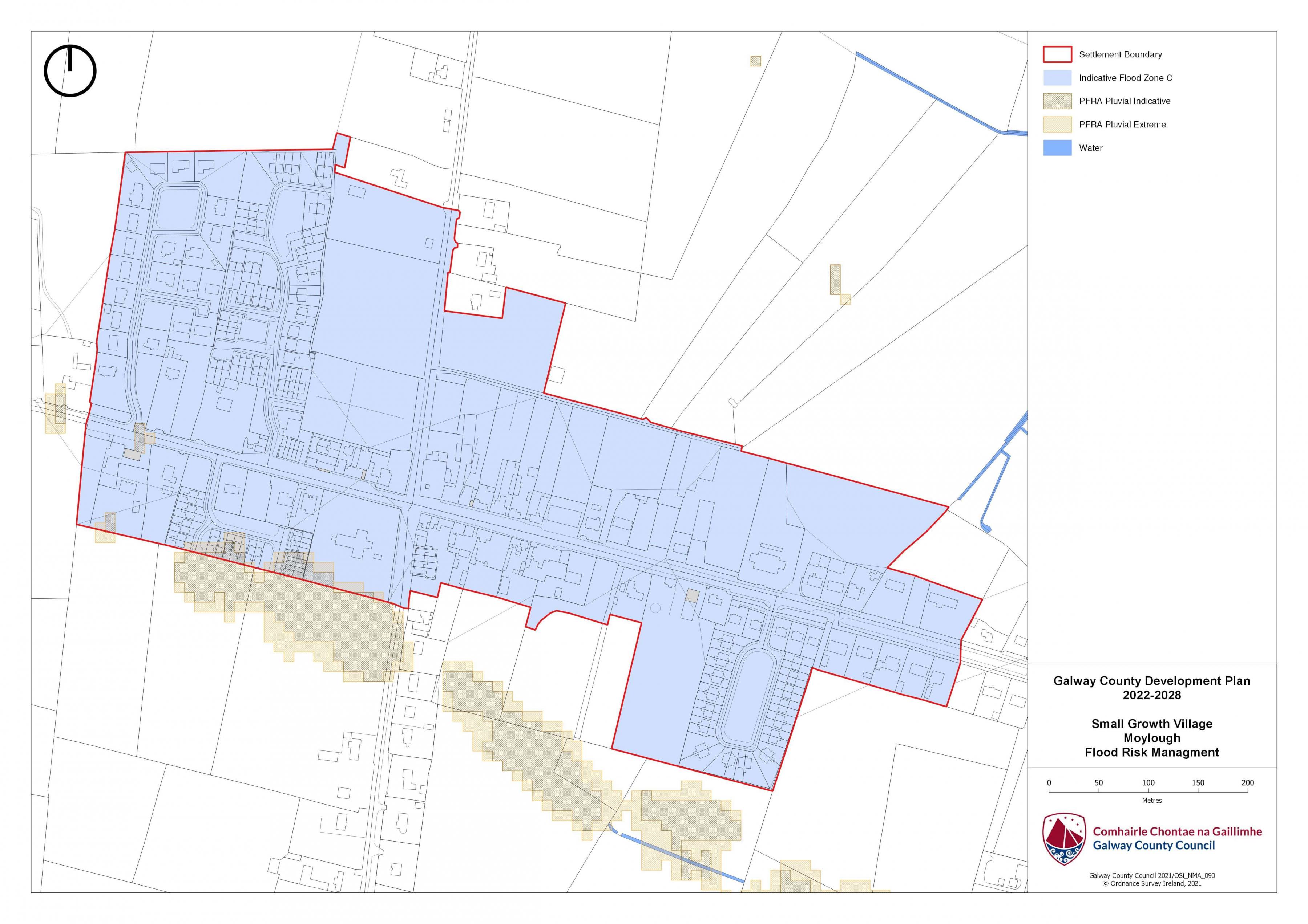
17.5 Flooding
With respect to lands within the village that are liable to flood risk, the Council will require any proposed developments to comply with ‘The Planning System and Flood Risk Management Guidelines for Planning Authorities (DEHLG, 2009) and Circular PL2/2014 and any amendment thereof. The Council, having regard to the nature and scope of development, may require the submission of Flood Risk Assessments, as appropriate, to assess the suitability of development proposals. There is a flood map identified for Moylough and is in accordance with the guidelines and circular referenced above.
|
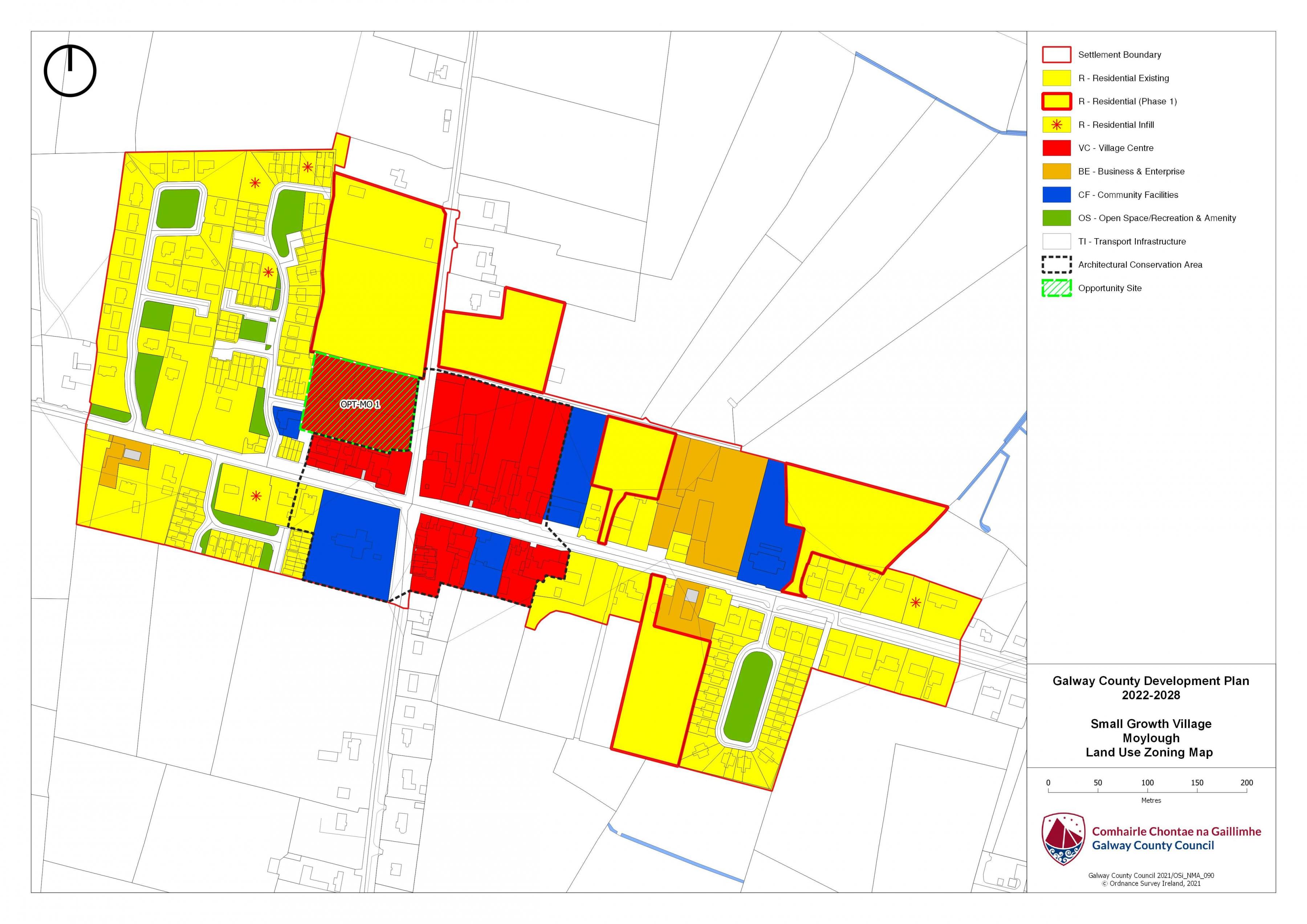
Land Use Zoning Policy Objectives for Moylough (Moylough Small Growth Village-MSGV) |
|
MSGV 1 Sustainable Village Centre Promote the development of Moylough village, as an intensive, high quality, well landscaped, human-scaled and accessible environment, with an appropriate mix of uses, including residential, commercial, service, tourism, enterprise, public and community uses as appropriate, that provide a range of retail services, facilities and amenities to the local community and visitors to the villages. The village centre and associated main street shall remain the primary focus for retail and service activity within these plan areas. MSGV 2 Sustainable Residential Communities Promote the development of appropriate and serviced lands to provide for high quality, well laid out and well landscaped sustainable residential communities with an appropriate mix of housing types and densities, together with complementary land uses such as community facilities, local services and public transport facilities, to serve the residential population of Moylough settlement plan. Protect existing residential amenities and facilitate compatible and appropriately designed new infill development, in accordance with the proper planning and sustainable development of the plan area. Specifically encourage living over the shop which can contribute to the vitality of the core and extend activity beyond business hours. MSGV 3 Local Development and Services To encourage and support the development of local facilities and services to meet the needs of the local community. MSGVV 4 Community Facilities To support the provision of additional community facilities and maintenance of the playground facilities, subject to resources being available. MSGV 5 Local Services and Business To facilitate the expansion of existing local services and businesses where appropriate and to facilitate the provision of further local employment opportunities in accordance with the proper planning and sustainable development of the area. MSGV 6 Small Scale Enterprises To encourage the provision of commercial and employment development within the village and in particular the provision of opportunities for small scale start up enterprises particularly on lands adjacent to the existing primary school which have a business and enterprise zoning. MSGV 7 Street scape Enhancement Works To facilitate the carrying out of streetscape enhancement works subject to resources being available. MSGV 8 Expansion of Public Infrastructure To support the expansion of public infrastructure within the village as required. MSGV 9 Connectivity to the Village New developments should be well integrated with the existing village and allow for easy and safe access and connectivity to the village centre and to the main facilities by foot and bicycle. MSGV 10 Opportunity Site To promote and encourage the appropriate re-development of the opportunity site identified below, which will contribute to the vitality and character of Moylough. |
|
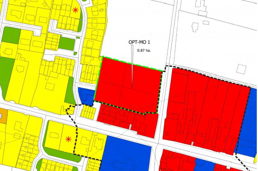
OPT-MO 1 Site Moylough. Brief Description: Large vacant site in the centre of Moylough Village. Area: The site area measures 0.87 HA Zoning: This site is zoned Village Centre. Current Land Use: Vacant. Opportunity: The site is located on the north side of the road to Mountbellew (N63). The primary means of access would be from the south-eastern corner of the site, however there may also potential additional access points from the east (R364), south-west via the N63. The site has great potential for future development. There has been a number of recent developments adjoining this site in the last number of years with the addition of residential units and a creche. This particular opportunity site has a Village Centre zoning that could provide additional complementary development to add to the existing development mix in the vicinity.
|
Moylough Land Use Zoning Map
Moylough Flood Risk Management Map
Contents
References
Observations
Observations