Propose to Move Corofin from Rural Settlements and Rural Countryside to Small Growth Villages
Chapter 2: Core Strategy, Settlement Strategy and Housing Strategy
Closed20 May, 2021, 09:00 - 30 Jul, 2021, 16:30
“The promotion of a balanced urban and rural county that ensures future growth is based on the principles of sustainable development , delivering a high quality living and working environment meeting the needs of all residents”
2.1 Introduction
The Core Strategy, Settlement Strategy and Housing Strategy has been prepared and informed by the National Planning Framework (NPF), the Implementation Roadmap for the NPF, The Regional Spatial and Economic Strategy (RSES) for the Northern and Western Region, and Section 28 Ministerial Guidelines. The Planning and Development Act 2000(as amended) requires an evidence-based Core Strategy to be included in all development plans. Its primary purpose is to ensure local authorities identify and reserve an appropriate amount of land in the right locations to meet population and housing targets. This is achieved through the expression of a medium to long term quantitative strategy for the spatial development of the area of the planning authority, which is consistent with the national and regional policy objectives as outlined in the National Planning Framework(NPF) and in the Regional Spatial Economic Strategy (RSES) for the Western Region. The Core Strategy includes a Settlement Hierarchy for the County transposing prescribed regional population targets set for county level to settlement and rural areas identified within the settlement hierarchy. The Core Strategy identifies the quantum, location and phasing of development in County Galway for the plan period which reflects the nationally and regionally defined population targets, settlement hierarchy while being cognisant of the availability of existing services, planned investment, sequential development and environmental requirements.
2.2 Purpose of Core Strategy
The purpose of the Core Strategy is to articulate a medium to long term based strategy for the spatial development of the county and in doing so demonstrate that the Development Plan and its policy objectives are consistent with national and regional development policy objectives set out in the NPF, the RSES, and specific planning policy requirements in section 28 Guidelines.
The preparation of a Core Strategy as part of the County Development Plan establishes a transparent evidence-based strategy for the sustainable spatial development of the county. It identifies the quantum, location and phasing of development of the Plan period linked back to the population target, in the form of a settlement hierarchy.
2.2.1 Statutory Requirements for the Core Strategy
The Planning and Development Act requires the Core Strategy to:
- Provide relevant information to demonstrate that the Development Plan and the Housing Strategy are consistent with the National Spatial Strategy and Regional Planning Guidelines;
- Take account of any policies of the Minister in relation to population targets;
- Quantify the requirements for zoning of lands for residential and or a mix of residential and other uses and quantify the housing units to be included in the area;
- Demonstrate how the zoning proposals accord with national policy and that development will take place on a phased basis;
- Demonstrate that in setting out policy objectives regarding retail development in the plan, the Planning Authority has had regard to any Ministerial guidelines that relate to retail;
- Set out a settlement hierarchy;
- Include a diagrammatic type Core Strategy Map/visual representation, depicting the above information;
- Include a Core Strategy Table, summarising the key statistics in the Core Strategy regarding the distribution of future population and housing and its alignment with the Regional Planning Guidelines.
2.3 Devising the Core Strategy
2.3.1 Project Ireland 2040: National Planning Framework (NPF)
Development Plans sit within a hierarchy of National and Regional Spatial plans at the top of which sits the NPF. The NPF is a high-level strategic plan that identifies future growth and development of the country to 2040. The main vision of the NPF is as follows:
- Developing a new region-focused strategy for managing growth;
- Linking this to a new 10-year investment plan. the Project Ireland 2040 National Development Plan 2018 -2027;
- Supporting and strengthening more environmentally focused planning at local level.
The NPF identifies a set of goals expressed as National Strategic Outcomes (NSO’s), which underpin the overarching vision for the Country.
One of the underlying principles of the NPF Strategy is to rebalance growth in the Country, which historically has disproportionately favoured growth in the Eastern and Midland Region. It enables all parts of the Country whether urban or rural, to successfully accommodate growth whilst recognising Dublin’s role as the principal economic driver of the country. The NPF targets 50% of overall national growth between five cities of Dublin, Cork, Limerick, Galway and Waterford. The NPF also references the development and implementation of a strategic metropolitan area spatial plan for Galway city and environs, including the settlements of Baile Chláir, Bearna and Oranmore. An important element of the growth strategy, intrinsic to the NPF, is securing compact and sustainable growth within the regions. Compact development is identified as a key priority of the NPF, which focusses on reusing previously developed “brownfield lands”, development of infill sites and buildings. To this end the NPF requires at least 30 % delivery of all new homes in settlements of over 1500 population to be within the existing built up footprint.
As part of the review process a full examination of lands in these towns were examined and Volume 2 of this plan identifies a quantum of lands in the Metropolitan plan (Baile Chláir, Bearna and Oranmore) that have been identified as Town centre/Infill Residential. This will also be carried through to the Key Towns, Strategic Potential and Self-Sustaining Towns as they are reviewed in the course of the next year.
2.3.2 Population Trends
Census 2016 recorded a population of 4,761,865 in April 2016, representing an increase of 3.8 % on Census 2011. County Galway’s population in 2016 was 179,390, which was an increase on the 2011 census, albeit at a slower rate from the levels experienced in previous inter-censal periods.
|
Year |
1991 |
1996 |
2002 |
2006 |
2011 |
2016 |
|---|---|---|---|---|---|---|
|
Population |
129,511 |
131,613 |
143,245 |
159,256 |
175,124 |
179,390 |
|
Actual Change |
- |
2,102 |
11,632 |
16,011 |
15,868 |
4,266 |
|
% Change |
- |
1.6 |
8.8 |
11.2 |
10.0 |
2.4 |
Table 2.1: Population and its Changing Trends in 1996-2016
As can be examined above, the county has had a steady growth of population since 1991. The growth rates had a moderate increase when comparing years 1996 and 2016, but considerable fluctuations can be observed across that period As illustrated above there was a major increase of growth rate during 1996-2002 from 1.6% to 8.8% which was then followed by more moderate increase to 11.2 in 2006 and a slight drop to 10% in 2011. This was followed by a drop to 2.4% in 2016 with a small growth in population.
2.3.3 Population Distribution
The population of the county is distributed across a network of urban and rural settlements and the open countryside. At the county level and based on the CSO’s parameters a total of 39,913 people (22.2%) were living in urban settlements in 2016. 139,477 (77.8%) were living in smaller towns and villages, as well as the rural remainder of the County. In 2011, census results showed a distribution between the urban and rural population as 22.6 % and 77.4% respectively. From analysis Galway West had a larger share of population decline, while there was a growing population mostly in Galway East and around major workplaces, such as Galway City and Tuam and along the M17 and M6. The towns of Athenry, Gort and Loughrea experienced an overall rate of growth considerably higher than the county average between 2011 and 2016, with the population increasing by 11.49% from 11,656 persons in 2011 to 12,995 persons in 2016. Thereafter the settlements identified as the Metropolitan Area had the highest growth rate, with the population growing by 4.33% from 7,894 persons in 2011 to 8,236 persons in 2016.
|
Settlement Typology |
Settlement |
Population CSO 2011 |
Population CSO 2016 |
Growth Rate 2011-2016 (%) |
|---|---|---|---|---|
|
Metropolitan Area |
Baile Chláir |
1,217 |
1,248 |
2.55 |
|
Bearna |
1,878 |
1,998 |
6.39 |
|
|
Oranmore |
4,799 |
4,990 |
3.98 |
|
|
Key Towns |
Ballinasloe |
6,659 |
6,662 |
0.05 |
|
Tuam |
8,242 |
8,767 |
6.37 |
|
|
Strategic Potential |
Athenry |
3,950 |
4,445 |
12.53 |
|
Self-Sustaining Towns |
Gort |
2,644 |
2,994 |
13.24 |
|
|
Loughrea |
5,062 |
5,556 |
9.76 |
|
Small Growth Towns |
Clifden |
2,056 |
1,597 |
-22.32 |
|
Maigh Cuilinn |
1,559 |
1,704 |
9.30 |
|
|
Oughterard |
1,333 |
1,318 |
-1.13 |
|
|
Portumna |
1,530 |
1,450 |
-5.23 |
|
|
Headford |
889 |
973 |
9.45 |
|
|
Small Growth Villages |
An Cheathrú Rua |
814 |
786 |
-3.44 |
|
An Spidéal |
250 |
237 |
-5.20 |
|
|
Ballygar |
660 |
687 |
4.09 |
|
|
Dunmore |
577 |
600 |
3.99 |
|
|
Glenamaddy |
500 |
480 |
-4.00 |
|
|
Kinvara |
620 |
730 |
17.74 |
|
|
Moylough |
503 |
518 |
2.98 |
|
|
|
|
|
|
|
|
Rural Settlements & Rural Area |
|
129,382 |
131,650 |
2.91 |
Table 2.2: Population Growth in County Galway 2011-2016
2.3.4 Implementation Roadmap for the National Planning Framework
The Implementation Roadmap for the National Planning Framework highlights the Governments focus on achieving alignment between national, regional and local planning and practice. This roadmap provides transitional population projections at a County scale in order to inform Development Plans for the period 2026 to 2031. The transitional populations for Galway City and county combined in table below:
|
Regions & Counties |
2016 |
2026 |
2031 |
|---|---|---|---|
|
Mid-West |
|
|
|
|
Galway |
258,000 |
300,000 - 308,500 |
322,000 - 334,500 |
Table 2.3: Implementation Roadmap for the National Planning Framework
2.3.5 Regional Spatial and Economic Strategy (RSES)
The RSES provides a high-level development framework for the Northern and Western Region (NWRA) that supports the implementation of the NPF and the relevant economic policies and objectives of Government. It provides a 12-year strategy to deliver the transformational change that is necessary to achieve the objectives and vision of the Assembly.
This RSES provides a robust strategy to deliver anticipated growth, building upon this region’s key strategic assets and opportunities and addressing challenges ahead. It also provides Regional Development Objectives that guide policy responses to ensure that people’s needs - such as access to housing, jobs, ease of travel and overall well-being - are met, up to 2040 and beyond.
The overarching ambition of the strategy is for a region that is “Vibrant, Connected, Natural, Smart and a Great Place to Live, consolidated by a strong settlement strategy focusing on ‘People’ and ‘Places’. The intention is that it becomes a living framework, which will be supported as required by detailed action plans, investment proposals and delivery partnerships.”
In this regard, the following Growth Ambitions are described as follows:
- PEOPLE AND PLACES - Compact growth will be pursued to ensure sustainable growth of more compact urban and rural settlements, supported by jobs, houses, services and amenities, rather than continued sprawl and unplanned, uneconomic growth.
- VIBRANT AMBITION - The NWRA believes that strong economic growth, which creates permanent, sustainable jobs, is best achieved by building a competitive and productive economy. Focusing policies on scale, investing in connectivity and our people whilst aggressively pursuing a low carbon approach to enhance our differentiation.
- NATURAL AMBITION - It has been identified that more strategic actions are required to prepare the region for what is to come and highlights the need to create a combined long term vision for the future of both energy supply and our ability to use renewable energy. To address our energy requirements our RSES emphasises the need for coordination, new thinking, investment, and skills to implement change. All considerations need to be cognisant of our natural resources, landscape, and heritage (natural, social and cultural).
- CONNECTED AMBITION - Accessibility and mobility within the region have a direct effect on the region’s economic competitiveness. It also has an effect on the attractiveness of the region as a favourable living and visiting environment. The RSES will support further investment in sustainable transport measures. In addition, to achieve our Vision for the region we need to strengthen our digital network and enable new technologies to work by ensuring that policies and systems are in place that can help people transition to a world much more digitally connected.
- INCLUSIVE AMBITION - One of the strongest foundations and emerging propositions this region has to build on is its ‘livability’. The region aspires to be one of the most liveable places in Europe with a commitment to sustainable and inclusive growth.
- INFRASTRUCTURE AMBITION - Provision and maintenance of economic infrastructure, such as energy, water, and wastewater, are key to delivering compact growth and a connected, vibrant, inclusive, resilient, and smart region.
In terms of demographics for the region, the population of the Northern and Western Region is dispersed unevenly and has historically had a lower level of urbanisation compared to other regions. However, Galway is identified as the fastest growing city in Ireland over the past 50 years. In 2016 the total population residing within the region was 847,442. This figure represents approximately 17.8% of the entire population of Ireland. The National Planning Framework provides a target growth rate for Galway of between 50%-55% to 2040.
The RSES has targeted the Metropolitan Area of Galway to grow by 27,500 to 2026 and by a further 14,500 to 2031 with a population of the city and suburbs accommodating 23,000 to 2026 and a further 12,000 to 2031. As the settlements of Baile Chláir, Bearna and Oranmore are in the county environs there is a population allocation to this part of the county of 4,500 by 2026.
|
|
Settlement |
Population 2016 |
% increase to 2040 (min) |
Proposed 2026 Uplift (min) |
Proposed 2030 Uplift (min) |
Transitional Population Target |
|---|---|---|---|---|---|---|
|
Metropolitan Area |
Galway City |
79,900 |
42,200 |
23,000 |
12,000 |
115,000 |
Table 2.4: Regional Spatial and Economic Strategy
2.3.6 Population Scenarios at Settlement/County Level
Several population projection scenarios for County Galway have been investigated up to 2031, ranging from “non-intervention” to “policy-intervention” scenarios. While, non-intervention methods are evidence-based projection relying on demographic trending of the State or County, the policy-intervention method seeks to facilitate the national and regional planning policy to achieve a balanced compact pattern of growth. The results for 2022 and 2028 which mark the Plan period are summarised in table 2.4.
|
Scenario |
Population 2022 |
Population 2028 |
|---|---|---|
|
Non-Intervention-A |
190,100 - 193,269 |
202,936 - 206,154 |
|
Non-Intervention -B |
207,329 |
212,415 |
|
Policy Intervention (Galway calcs-City Calcs |
195,855 |
212,432 |
|
Policy Intervention (Midway NPF target) |
192,356 |
205,900 |
|
Policy Intervention (High NPF target) |
195,056 |
211,100 |
|
ESRI Figures (Avg.ESRI NPF and ESRI Baseline) |
187,831 |
198,750 |
Table 2.5: Results of Population Projections in Different Scenarios
Accordingly, two variations of the non-intervention scenario were explored. The first variation relies on the State projection figures provided by CSO StatBank, applying the growth rate of the State to the County 2016 onwards. The second variation utilises the Cohort Component Method (CCM) method, known as the best-in-class methodology for demographic projection. CCM projects the population by age groups and sex using survival rates, net migration, and birth rates over the Plan period.
The policy-intervention scenario on the other hand relies on the NPF/RSES population targets, utilising these figures as the fixed variables to interpolate the required level of change per annum within the County. Different variations under this scenario were explored: (1) performing the calculation for both City and Galway using the NPF and RSES high population targets over the Plan period and estimating the County population by subtracting City from the overall figure, (2) taking the mid-way NPF population target and performing the calculations, (3) taking the high NPF population target and performing the calculations. The third variation of policy-intervention scenario was selected for the purpose of HNDA and the Core Strategy.
With the ESRI research work “Structural Housing Demand at County Level” published on 14th December 2020, the “Housing Supply Target Methodology for Development Planning” published by DHLGH in December 2020, and the Ministerial Letter advising these publications as the most up to date approach towards demand projection, a third alternative was available for the population projection. In this alternative, ESRI NPF and ESRI Baseline figures were taken to calculate an adjusted population projection scenario for the County. However, as illustrated in the Table above, while the non-intervention- and policy-intervention scenarios show more consistency, especially in the long-run up to 2028, the ESRI results stands out by a considerable deviation which is not fully reflective of the on-going demographic trends in the County. Therefore, the policy-intervention relying on the high NPF population target is taken as the preferred scenario. The NPF sets out a targeted pattern of growth for Galway to 2026 with the projected population to range between 300,000 to 308,500 persons. Specific population targets for Galway City are also set out in the RSES. As per Variation no. 5 of the City Development Plan 2017-2023, the target for the city is to reach a population of 102,900 by 2026, that is an increase of 23,000 people from the Census 2016 City and Suburbs population of 79,900. Longer term to 2031, the target for the city is to grow by a further 12,000 to 114,900 population. Taking the 308,500 as the anticipated population for Galway, the population projection of the County Galway will be as the following:
|
Settlement |
Census 2016 |
NPF/RSES Population Target 2026 |
NPF/RSES Population Target 2031 |
|---|---|---|---|
|
City and Suburbs |
80,000 |
23,000 |
12,000 |
|
Galway County |
180,000 |
25,500 |
14,000 |
|
Total |
260,000 |
48,500 |
26,000 |
Table 2.6: Population Projections for Galway
In this policy intervention scenario, the above population targets are used as the fixed variables and then an interpolation of the required level of change per annum was developed from baseline year 2016 to NPF/RSES target years 2026 and 2031; thus, producing annualised figures over the period of 2022 and 2028 which is the lifetime of the Development Plan.
|
Year |
Total Population in County Galway |
Annual Population Increase during year |
Annual Population Increase 2022-2028 |
Total Population Increase 2022-2028 |
Total Population Increase 2016-2028 |
|---|---|---|---|---|---|
|
2006 |
159,256 |
68.70% |
|
|
|
|
2011 |
175,124 |
69.90% |
|
|
|
|
2016 |
179,390 |
69.50% |
|
|
|
|
2017 |
182,001 |
1.46% |
2,611 |
|
|
|
2018 |
184,612 |
1.46% |
2,611 |
|
|
|
2019 |
187,223 |
1.46% |
2,611 |
|
|
|
2020 |
189,834 |
1.46% |
2,611 |
|
|
|
2021 |
192,445 |
1.46% |
2,611 |
|
|
|
2022
|
195,056 |
1.46% |
2,611 |
|
|
|
2023 |
197,667 |
1.46% |
2,611 |
|
|
|
2024 |
202,278 |
1.46% |
2,611 |
|
|
|
2025 |
2028,889 |
1.46% |
2,611 |
|
|
|
2026 |
205,500 |
1.46% |
2,611 |
|
|
|
2027 |
208,300 |
1.36% |
2,800 |
|
|
|
2028 |
211,100 |
1.36% |
2,800 |
18,655 |
31,810 |
Table 2.7: Projected Population Growth Over the Plan Period based upon NPF/RSES 2026 & 2031 Targets
2.3.7 Average Household Size
The census 2016 data indicates that Galway has a population to household size of 2.8 which is slightly higher than the state average of 2.7. However, the NPF states that this state average is expected to decline to around 2.5 by 2040, while also acknowledging that household sizes in urban areas tend to be smaller than in suburbs or rural parts of the county. As outlined in the Housing Strategy (Appendix 2) an analysis of historical trends of household size in the county was carried out to determine the evidence based graduated reduction in average household size, which has been identified as 2.5 for the plan period. By applying the relevant household size to the projected population increases, it is possible to forecast required household numbers to 2028 and beyond.
2.3.8 Household Size Cohort
As outlined in Section 6.6 of the NPF, household composition and projections are informative evidence input which can assist with building up an understanding of the future demand market of the county. Analysis of the historic trending of the households with a concentration on the household size cohort per household would help to identify the patterns of change and apply that to the projected households to estimate how the composition of households may change during the plan period. This analysis demonstrates a trend towards smaller size households, including single to two persons households. However within the county area there is still a relative demand for large households.
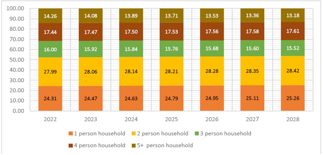
Table 2.8: Household Size Cohort
2.3.9 Galway’s Core Strategy
Galway’s core strategy has been informed by the principal elements of the RSES growth strategy in conjunction with the environmental sensitivities of the county. It is based on strengthening its strong urban settlements, whilst simultaneously protecting and supporting population in the rural areas, which also provides valuable natural resources, biodiversity, environmental quality and landscape features. Population and economic growth will be accommodated primarily in the MASP, Key Towns, Strategic Potential and Self-Sustaining Towns with recognition of the potential for the smaller towns and villages to develop at a sustainable rate.
The focus on the core strategy for County Galway can be summarised as follows:
- Prioritise targeted population and economic growth to the MASP, Key Towns, Strategic Towns and Self-Sustaining Towns and promote their continued sustainable growth;
- Capitalise on the location of the settlements within the MASP, to drive linkages and synergies between Galway city and the wider MASP area;
- Support the Key Towns and Strategic Potential town which are important local drivers providing levels of jobs and services for the resident population and surrounding catchments;
- Support Self-Sustaining Towns requiring contained growth, focusing on investment in services employment and infrastructure whilst providing a viable alternative to single housing in the countryside;
- Support the Small Growth Towns and Small Growth Villages as areas for local services, residential and employment potential;
- Contribute to urban regeneration lands and the development of brownfield sites for the revitalisation of settlements;
- Management of urban generated growth in Rural Areas under urban influence, by ensuring single houses in the open countryside are based on the core consideration of demonstrable economic or social need to live in the rural area in addition to compliance with statutory guidelines, plans and having regard to ensuring the viability of villages and towns;
- All lands identified for development are in accordance with the “Tiered Approach to Land Use Zoning” as set out in NPF.
The Settlement Strategy for future growth in the county is detailed further in section 2.4 of this chapter.
2.3.10 Overview of Approach to Core Strategy
The Core Strategy has been prepared with the following parameters and the Housing Strategy and HNDA. It is considered that the Core Strategy table overleaf which outlines the approach by the Council has been informed by the following:
- The allocation of population growth to the settlements on a sustainable tiered approach based on the settlement hierarchy set out in the RSES (2019), the infrastructural services, demand, past delivery and potential growth means that the settlements will grow at an appropriate rate and at a more self-sufficient level, thereby reducing the need to commute;
- The distribution of many land use types within settlement boundaries including a mix of uses in the centre of settlements which will facilitate reduced travel demand and also increase usage of sustainable modes of transport;
- A number of different land uses are permitted or open for consideration in the land use zonings within these settlements. This allows for the integration of various uses in proximity to each other, thereby reducing the need to travel in the first instance, and secondly encourages walking and cycling;
- The density approach is reflective of the higher order settlements i.e MASP, Key Towns, Strategic Potential and Self-Sustaining Towns and other towns and villages and the existing built environment;
- The quantum, location and distribution of new development has had regard to the capacity of existing and planned wastewater service infrastructure;
- Population growth has been identified within strong employment and service centres of all sizes, supported by continued employment growth;
- Environmental considerations have been taken in account in the preparation of the Core Strategy.
2.3.11 Key Principles
The position of each town in the settlement hierarchy has been clearly linked to the quantitative population allocations and the distribution of future population and household growth. This is in accordance with the “Tiered Approach to Land Use Zoning” set out in the NPF.
- Compact Growth
In accordance with the principles of compact growth, at least 30 % of housing within settlements is to be within the existing built up footprint area in conjunction with sequential development of settlements. There are limiting factors which are applicable eg the historic formation of many of the main towns in County Galway, flooding implications, inadequate access, limited and fragmented land holdings and the requirement to facilitate retail development in these locations in accordance with the sequential test under the Retail Planning Guidelines for Planning Authorities (DECLG,2012). An analysis of the potential capacity of town centre/infill residential indicates that approximately 1,820 units could be delivered on these lands.
- Climate Change and Environmental Sensitivity
Climate Change has an increasing role to play in how the county is planned in the future. The plan has a critical role to play in ensuring the communities develop having regard to sustainable infrastructure networks which build resilience to climate change. Consideration is given to; ground and surface water vulnerability and any potential environmental impact (including SEA, HAD, EU Water Framework Directive, River Basin Management Plans and Flood Risk Management) requirements; availability of services and infrastructure; potential for economic and social development of the settlement; the sequential test; ground and surface water vulnerability; planning history and market availability/choice. A Strategic Environmental Assessment and Appropriate Assessment has been prepared in tandem with the Core Strategy. The Core Strategy has had regard to both assessments with any changes/recommendations incorporated into the strategy.
- Retail Development
The Core Strategy is also statutorily required to contain information to show that in setting out policy objectives for retail development, the Planning Authority has had regard to the Retail Planning Guidelines and that the estimates of required future retail development are based on and take account of the specific population targets. In addressing this requirement, Galway County Council intends to prepare a Retail Strategy in conjunction/consultation with Galway City Council as set out in Chapter 5 Economic, Enterprise and Retail, of this plan. This Retail Strategy shall take account of the above requirements. Chapter 5 of the plan sets out the retail hierarchy for the County and provides a number of other policy objectives regarding retail management, set within the framework of the Retail Planning Guidelines for Planning Authorities 2012. The retail hierarchy aligns with the designation of Settlement Hierarchy and the population projections within the Core Strategy, with the MASP, Key Towns, Area of Strategic Potential, Self-Sustaining Towns, as the main focus for new retail developments. Appropriately scaled new retail development in centrally located sites within ‘Small Growth Towns and Small Growth Villages’ shall also be encouraged.
- Economic Development and Other Land Uses
Land uses such as employment/industry uses and transport options have also informed the Core Strategy and Settlement Hierarchy in terms of assisting in identifying the role and capacity that individual settlements have for development and also in determining where the population allocations under the Core Strategy should go. The Spatial and Core Strategy, in line with the RSES, recognises priority areas in relation to economic activity for the County, such as the provisions for a Strategic Economic Corridor to the eastern area of the County, the role of urban areas in sustaining economic buoyancy, the importance of attracting foreign direct investment, promoting indigenous industry, the food and craft sector, tourism, renewable energy and the smart economy, which are all detailed in Chapter 5 of the Plan.
- A Tiered Approach to Development
The NPF sets out a new standardised methodology that addresses the differentiation between zoned land that is available for development and zoned land that requires significant further investment in services for infrastructure for development where they are able to connect to existing development services, i.e road and footpath access including public lighting, foul sewer drainage, surface water drainage and water supply, for which there is capacity available and can therefore accommodate new development. In accordance with this, the Plan has been prepared in accordance with the National Policy Objective 72a requiring Planning authorities to apply a standardised, tiered approach to differentiate between i) zoned land that is serviced and ii) zoned land that is serviceable within the life of the plan. As a result of this assessment, growth has been targeted in the towns and villages within the county that have available wastewater and water capacity.
2.3.12 Core Strategy Map & Core Strategy Table
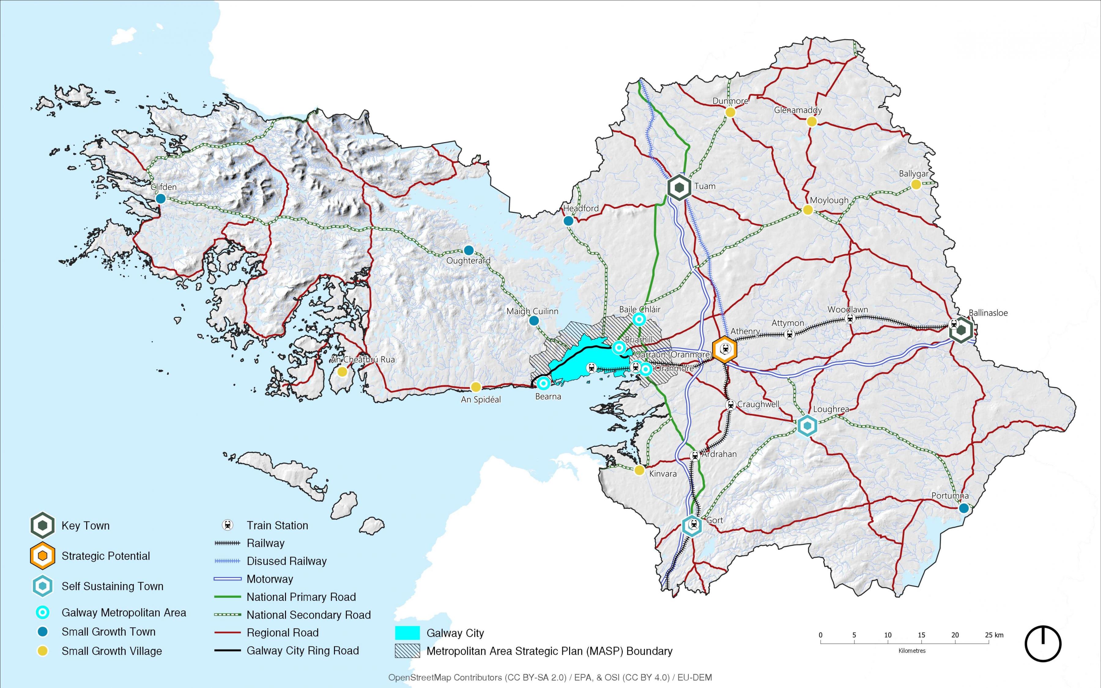
The Core Strategy Map (Map 2.1) is a diagrammatic representation of the spatial planning Strategy for County Galway. The Core Strategy table 4.2 on page 39 sets out the population projections and household allocation for each settlement and rural countryside up to 2028. Settlement Plans in Volume 2 reflect these figures and indicates the quantum of future development for the plan period.
Map No. 2.1: Core Strategy Map 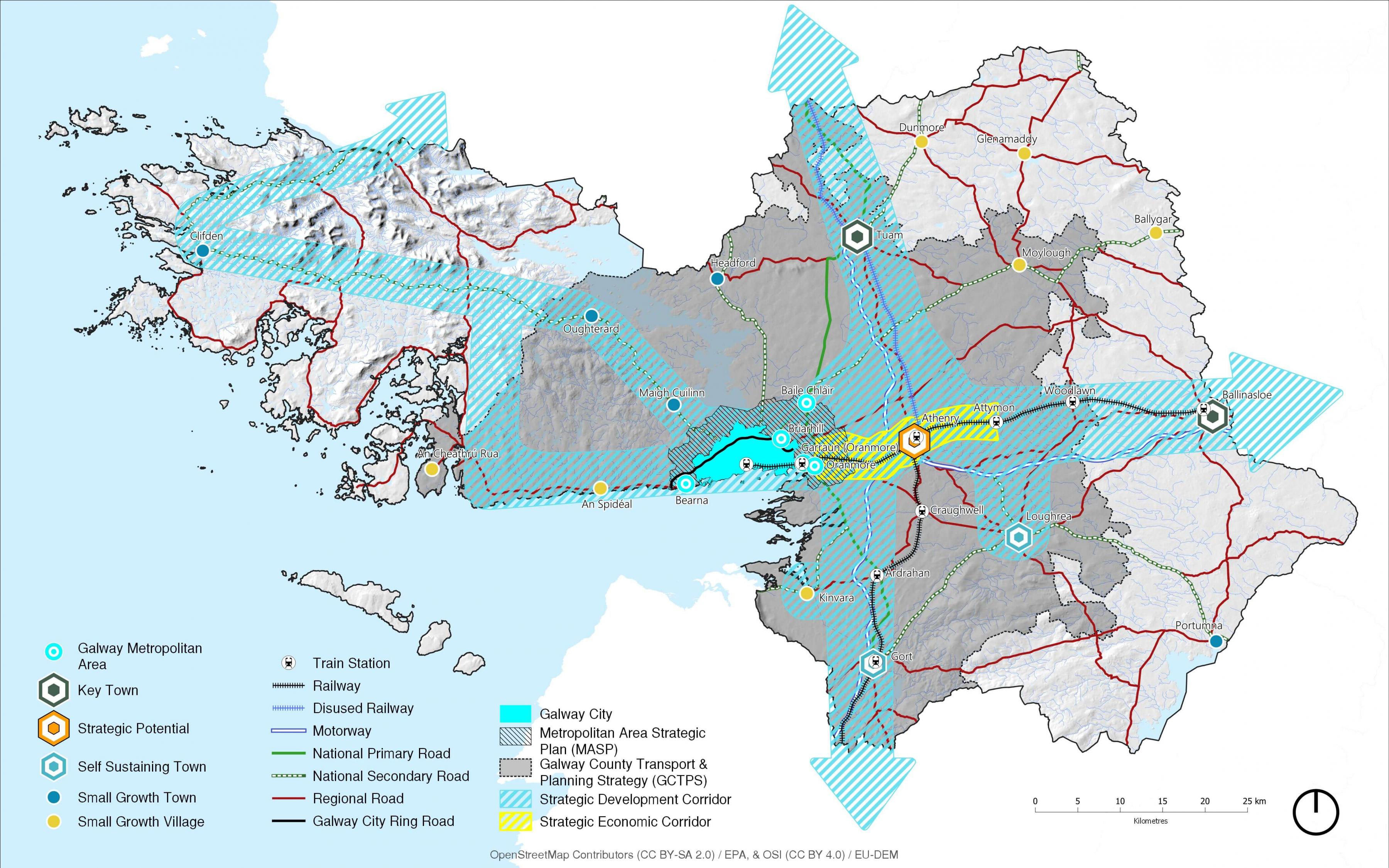
|
Settlement Typology |
Settlement |
Population CSO 2016 |
Core Stratgey 2022-2028 Population Allocation |
Housing Units |
Density |
Housing Land Requirement |
Up to 30% of Residential Units into Built Up Footprint |
|
|---|---|---|---|---|---|---|---|---|
|
County |
Galway |
179,390 |
18,655 |
7,469 |
|
283 |
1,427 |
|
|
Metropolitan Area |
Baile Chláir |
1,248 |
975 |
390 |
30 |
13.00 |
117.00 |
|
|
Bearna |
1,998 |
750 |
300 |
30 |
10.00 |
90.00 |
||
|
Oranmore |
4,990 |
1,540 |
616 |
30 |
20.53 |
184.80 |
||
|
Briarhill** |
0 |
977 |
391 |
30 |
13.03 |
0 |
||
|
Garraun** |
0 |
1258 |
503 |
35 |
14.38 |
0 |
||
|
Totals |
|
8,236 |
5,500 |
2,200 |
|
69.38 |
660.00 |
|
|
Key Towns |
Ballinasloe |
6,662 |
1,999 |
799 |
30 |
26.65 |
239.38 |
|
|
Tuam |
8,767 |
2,630 |
1,052 |
30 |
35.07 |
315.61 |
||
|
Totals |
|
15,429 |
4,629 |
1,851 |
|
62 |
555 |
|
|
Strategic Potential |
Athenry |
4,445 |
1,350 |
540 |
20 |
27.00 |
162.00 |
|
|
Totals |
|
4,445 |
1,350 |
540 |
20 |
27.00 | 162.00 | |
|
Self-Sustaining Towns |
Gort |
2,994 |
800 |
320 |
20 |
16.00 |
96.00 |
|
|
|
Loughrea |
5,556 |
1,400 |
560 |
20 |
28.00 |
168.00 |
|
|
Totals |
|
8,550 |
2,200 |
880 |
|
44 |
264 |
|
|
Small Growth Towns |
Clifden |
1,597 |
470 |
195 |
16 |
12.19 |
58.50 |
|
| Headford | 973 | 290 | 116 | 16 | 7.25 | 34.80 | ||
|
Maigh Cuilinn |
1,704 |
350 |
140 |
16 |
8.75 |
42.00 |
||
|
Oughterard |
1,318 |
350 |
140 |
16 |
8.75 |
42.00 |
||
|
Portumna |
1,450 |
300 |
120 |
16 |
7.50 |
36.00 |
||
|
Totals |
|
6,069 |
1,760 |
711 |
|
45 |
215.70 |
|
|
Small Growth Villages |
An Cheathrú Rua |
781 |
150 |
60 |
11 |
5.45 |
18.00 |
|
|
An Spidéal |
237 |
55 |
22 |
11 |
2.00 |
6.60 |
||
|
Ballygar |
687 |
175 |
70 |
11 |
6.36 |
21.00 |
||
|
Dunmore |
600 |
120 |
48 |
11 |
4.36 |
14.40 |
||
|
Glenamaddy |
480 |
130 |
52 |
11 |
4.73 |
15.60 |
||
|
Kinvara |
730 |
200 |
80 |
11 |
7.27 |
24.00 |
||
|
Moylough |
518 |
125 |
50 |
11 |
4.55 |
15.00 |
||
| Totals | 4,038 | 955 | 382 | 35 | 115 | |||
|
Totals per Towns and Villages |
|
47,740 |
16,394 |
6,564 |
|
|
|
|
|
Rural Settlements & Rural Area |
|
131,650 |
2,261 |
904 |
|
|
|
Table 2.9 Core Strategy Table
** Urban Framework Plans-Prepared for Briarhill and Garraun, these are contained in Volume 2 of the Galway County Development Plan 2022-2028.
2.3.14 Core Strategy Policy Objectives
Galway County Council shall ensure that the future spatial development of Galway is informed by means of a plan led approach, directing residential and employment generating development to locations in accordance with national and regional policy and with environmental carrying capacity, which can support investment in public infrastructure and services and which is sensitive to the physical character of the built and natural environment. This approach is enshrined in several Core Strategy Policy Objectives as below:
|
Policy Objectives Overarching Core Strategy |
|
CS 1 Implementation To secure the implementation of the Core Strategy and the Settlement Hierarchy in so far as practicable, by directing sustainable growth towards the designated settlement. CS 2 Compact Growth To achieve compact growth through the delivery of new homes in urban areas within the existing built up footprint of settlements, by developing infill, brownfield and regeneration sites and prioritising underutilised land in preference to greenfield sites. CS 3 Population Growth To support and manage the self-sufficient sustainable development of all settlements in a planned manner, with population growth and the development of economic, physical and social infrastructure. CS4 Initiatives Promote measures to reduce vacancy and the underuse of existing building stock and support initiatives that promote the reuse, refurbishment and retrofitting of existing buildings within urban centres and targeted settlements in the County. CS5 Population within Tiers It is a policy objective of the Council to support the delivery of the population projections within the different settlement tiers of the Core Strategy. Where individual settlements are not progressing to reach their population allocation at the half way point in the lifetime of the plan the population allocation maybe redistributed within the individual tier subject to servicing and the proper planning and sustainable development of the area. |
2.3.15 Monitoring and Management
With the adoption of specific population targets for the county and each settlement/settlement typology, the monitoring of the extent of residential development is required to ensure that development occurs in a coherent, reasoned and evidence-based manner.
|
Policy Objectives Monitoring and Management |
|
MM 1 Monitoring and Management The Council shall, in conjunction with the Regional Assembly and other sources as relevant, implement the monitoring programme as set out in the SEA Environmental Report and Statement. This will include the preparation of stand-alone SEA Monitoring Reports:
|
2.4 Settlement Hierarchy
The Settlement Hierarchy of this plan has been developed to take account of the function and role of each of the identified settlements in accordance and close alignment with the identified settlement hierarchy in the RSES.
2.4.1 Purpose
A Settlement Hierarchy is a spatial expression of sustainable population distribution, settlement hierarchy and settlement role. It provides a strategic direction to the appropriate management of growth, investment and resources in accordance with the Core Strategy in a climate resilient manner. With the identification of projected population growth for County Galway within the lifetime of this Plan and the identification of the relevant tiers of the settlement hierarchy, housing land has been allocated to deliver new homes to meet a growing population in a sustainable manner. In terms of the settlements, this land can be viewed on the Land Use Zoning Maps in Volume 2 of this plan, and in Local Area Plans.
2.4.2 Settlement Hierarchy Context
The Central Statistics Office (CSO) defines ‘rural’ as the areas outside settlements with a population of 1,500 or more people. This includes smaller settlements of fewer than 1,500 people and individual dwellings in the countryside. The CSO defines a settlement of more than 1,500 people as ‘urban’. These definitions have been carried through into the NPF. The settlement hierarchy is categorised with these parameters , but also settlements of similar function are grouped together.
2.4.3 Settlement Hierarchy
Consistency and alignment between National, Regional and Local plans is a requirement of the Planning and Development Act 2000(as amended). Galway’s planned framework for growth is therefore guided and directed by the RSES. The RSES has identified a robust evidence-based approach to derive a settlement hierarchy which identifies locations for population and employment growth with matched infrastructure and service investment to satisfy and accommodate future growth needs. This relates to Galway as follows:
|
Settlement |
Settlement Category |
Description |
Settlement |
|
1 |
Metropolitan Area Strategic Plan |
The MASP has been identified to accommodate critical mass in population growth within the area that will ensure the vitality and appeal of Galway City and the surrounding towns and villages |
Baile Chláir Bearna Oranmore Garraun Briarhill |
|
2 |
Key Towns |
Towns that are regionally strategic employment centres of significant scale that can act as regional drivers that complement and support the higher order areas within the settlement hierarchy (Galway MASP). |
Tuam Ballinasloe
|
|
3 |
Strategic Potential |
Large economically active service centre that provides employment for the surrounding areas |
Athenry |
|
4 |
Self Sustaining Towns
|
Self Sustaining Towns with high levels of population growth and a limited employment base which are reliant on other areas for employment and/or services and which require targeted “catch-up” investment to become more sustaining. |
Gort Loughrea |
|
5 |
Small Growth Towns
|
Small Towns with local service and employment potential. There is a need to promote regeneration and revitalisation of towns and support local enterprise and employment opportunities to ensure their viability as service centres for surrounding rural areas |
Clifden Maigh Cuilinn Oughterard Portumna Headford |
|
6 |
Small Growth Villages |
Small villages with local service and employment potential. |
An Chearthrú Rua An Spidéal Ballygar Dunmore Glenamaddy Kinvara Moylough |
|
7 |
Rural Settlements and Rural Countryside |
Rural villages and the wider rural region. Rural encompasses villages and the wider open countryside. There may not be good public transport or regional connections and maybe highly car dependent. The open countryside provides for rural economies and rural communities, based on agriculture, forestry, tourism and rural enterprise. |
Craughwell, Corofin, Clarinbridge, Ardrahan, Kilcolgan,An Tulaigh/Baile na hAbhann, Cor an Dola, Woodlawn, Kilconnell,New Inn, Ballymacward, An Carn Mór, Lackagh, Turloughmore, Abbeyknockmoy, Cluain Bú, Eanach Dhúin, Ahascragh, Attymon, Monivea, Eyrecourt, Banagher, Aughrim, Caltra, Clonfert, Kiltormer, Menlough, Lawrencetown, Fohenagh, Killoran, Castleblakeney, Ballinamore Bridge, Gorteen, Cappataggle, Willimastown, Kilkerrin, Barnaderg, Belclare, Kilbennan, Briarfield, Newbridge, Ballymoe, Milltown, Kilconly, Caherlistrane, Brownsgrove, Sylane, Lavally, Foxhall, Newbridge, Cashla, Kiltevna, Glinsk, Ballyglunin, Laragh More, Woodford, Killimor, Ballymana, Esker, Carrabane, Kiltullagh, Derrydonnell Beg, Ballinderreen, Kilchreest, Ballinakill, Moyglass, Peterswell, Killeenadeema, Drim, Kilconieran, Labane, Tynagh, Kilreekil, Abbey, Bullaun, Castledaly, Coose, Newcastle, Cooloo, Shanaglish, Na Forbacha, An Cnoc, Na Minna, Ros an Mhíl, Rosscahill, Tulaigh Mhic Aodháin, Leitir Móir, Cill Chiaráin, Cill Rónáin, Roundstone, Carna, Tully/Renvyle, Glinsk, Leitir Mealláin, Béal an Daingin, Tullycross, Rosmuc, An Fhairche, Leenane, Cleggan, Letterfrack, Casla, Corr na Móna, Ballyconneely , Sraith Salach, Claddaghduff, An Mám, Maam Cross, An Aird Mhóir, Maree, Kilbeacanty, Cloghanover, Camas. |
*Urban Framework Plans-Prepared for Briarhill and Garraun, these are contained in Volume 2 of the Galway County Development Plan 2022-2028.
Table 2.9: Settlement Hierarchy
2.4.4 Future Settlement Growth
Complying with the strategic outcomes of the NPF and the five growth ambitions of the RSES, it is essential that the spatial approach to sustainably developing County Galway is reflective of these approaches. Future development will be directed in the following manner:
- Growth, with a focus on town centre/infill residential in levels 1,2,3 and 4 where applicable and infill residential on residential zoned lands in all levels;
- Promote Opportunity Sites in levels 5 and 6 as outlined in Volume 2 of the plan;
- Support the designation of the MASP and the settlements of Baile Chláir, Bearna and Oranmore;
- Support the concept of the Urban Framework Plans for Briarhill and Garraun;
- Develop the designated Key Towns of Ballinasloe and Tuam of sufficient scale and quality to be a driver of regional growth, investment and prosperity, followed by Strategic Potential Town, Self-Sustaining Towns and Small Growth Towns and Villages to grow to a sustainable level;
- Strengthening villages in level 7 as an alternative to rural housing in the open countryside;
- Making better use of under-utilised land and buildings including vacant, derelict and under occupied buildings;
- Supporting, facilitating and promoting a transition to a low carbon society;
- Strengthening town and village centres to meet their full potential;
- Aligning population, employment, community and housing growth in a balanced fashion;
The county’s most significant place-making challenge will be to plan and deliver future development in a way that moves more towards self-sustaining, rather than commuter driven activity, therefore allowing its towns, villages and rural components to play to their strengths, while above all, moving from a sprawl-led development model.
The Settlement Hierarchy seeks to strengthen the urban fabric of the county, with an emphasis on building critical mass in the MASP, Key Towns, Strategic Potential Town, the Self-Sustaining Growth Towns and Self-Sustaining Towns. The focus is on achieving the consolidated growth of the settlements, with a significantly high proportion of housing in the existing built-up footprints of each settlement, strengthening town centres to their full potential by utilising under-utilised land and buildings and developing the settlements in a sequential manner. Two Urban Framework Plans have been prepared for Briarhill and Garraun and are contained in Volume 2 of the plan. The UFP for Garraun is centred around the train station at Oranmore. The Briarhill UFP is integral to the IDA/Employment sites at Parkmore and will be connected to an existing public transport corridor.
2.4.5 MASP
The Galway Metropolitan Area, the subject of the MASP, extends from Bearna in the west to include Galway City and suburbs and continuing eastwards to Baile Chláir and Oranmore. The eastern Metropolitan Area includes planned growth areas at Ardaun, Garraun and Briarhill.
Garraun and Briarhill are identified as key strategic growth areas within County Galway that will contribute significantly to meeting the aspirations of the NPF and RSES. Urban Framework Plans have been prepared by Galway County Council for both Garraun and Briarhill and are included Volume 2 of this plan. The role of the Metropolitan Area is to accommodate population growth within the area that will ensure the vitality and appeal of Galway City and the surrounding towns and village settlements. A robust Metropolitan Area, incorporating high quality and integrated physical infrastructure and community facilities will strengthen the role of the Northern and Western region and help it to compete at a national level.
2.4.6 Key Towns
The Key Towns are to grow their population by at least 30%, relative to Census 2016 (i.e., Ballinasloe and Tuam). In relation to Ballinasloe, one of the Key Future Priorities for the town includes: “realising the town’s potential as a ‘County Town’, ensuring a balance of development in the town centre of Ballinasloe, and providing for compact growth and brownfield development, revitalising Dunlo Street, Market Square, Society Street and Main Street, and to reduce vacancies and support the vitality and vibrancy of these core shopping streets/side streets and the town centre.”
The Key Future Priorities for Tuam differ slightly, as the focus for the town lies in promoting Tuam as a destination for business, however, the following priorities apply: “to develop Tuam as the focus for future development in North Galway providing the infrastructure and services for its surrounding small towns/villages and rural lands”, as well as to “capitalise on the compact urban form of Tuam town centre by encouraging greater connectivity for new development which promotes and encourages walking and cycling ensuring that principles of sustainable transportation along with practical design measures become central to the development of new neighbourhood.”
2.4.7 Area of Strategic Potential
Athenry is identified as an Area of Strategic Potential. Athenry has easy access to the Galway-Dublin railway line and the Galway -Limerick railway line. The town has existing access to broadband infrastructure and associated infrastructure services. Athenry can develop further and accommodate enterprises, e.g. Economic Corridor from Oranmore to Athenry. Economic corridors particularly employment corridors such as the Oranmore – Athenry Strategic corridor must be developed/promoted and serviced to high international standards to attract further Foreign Direct Investment and indigenous industries/ businesses, building on the existing strategic location and infrastructure. This corridor will be promoted sustainably as a centre for major national and international enterprises in a manner that shall be further defined in local planning policies.
2.4.8 Self Sustaining Towns
Gort and Loughrea have been identified as Self-Sustaining Towns with high levels of population growth, however there are limited employment base which are reliant on other areas for employment and/or services and which require targeted “catch-up” investment to become more sustaining. The growth strategy for both Gort and Loughrea is to consolidate their designation as Self -Sustaining Town’s and continue to support expansion of their employment base. In addition, residential development will be facilitated that will support the sustainable growth of the towns.
2.4.9 Small Growth Towns
The towns listed in this category have an important function in supporting the development of local areas. The residential development will be proportioned to the growth of the towns. The growth strategy will focus on the localised sustainable growth that meets the needs of the local population and wider hinterland. Economic and employment related development that would strengthen the local employment base and reduce the dependence on commuting will be supported where appropriate. Volume 2 of this plan provides a Written Statement and associated Land Use Zoning Maps.
2.4.10 Small Growth Villages
The villages listed in this category have an important function in supporting the development of local areas. The residential development will be proportioned to the growth of the villages. The growth strategy will focus on the localised sustainable growth that meets the needs of the local population and wider rural hinterland. Volume 2 of this plan provides a Written Statement and associated Land Use Zoning Maps.
2.4.11 Rural
Rural population will continue to be supported through the villages and through a sustainable approach to maintaining the rural economy and population, balanced against reasonable environmental protection. Support for housing and repopulation, as necessary, taking place within towns and villages will help to act as a viable alternative to one-off housing in the open countryside and will contribute to the principle of compact growth. A national programme will be developed for ‘new homes in small towns and villages’ with local authorities, public infrastructure agencies such as Irish Water, and local communities providing serviced sites with appropriate infrastructure acting as a viable alternative to houses in the open countryside. The open countryside is and will continue to be, a living and lived-in landscape focusing on the requirements of rural economies and rural communities, based on agriculture, forestry, tourism and rural enterprise, while at the same time avoiding ribbon and over-spill development from urban areas and protecting environmental qualities.
The Council will ensure that development of the open countryside takes place in a way that is compatible with the protection of key economic, environmental, biodiversity and cultural / heritage assets such as the road network, water quality and important landscapes. In accordance with the RSES, it will be necessary to demonstrate a ‘functional economic or social requirement’ for housing need in Rural areas under urban influence. This is represented by the Galway County Transport & Planning Strategy (GCTPS) on the core strategy map above and detailed analysis is contained in Chapter 4 Rural Living and Development.
2.4.12 Rural Typologies
As required by the Core Strategy Guidance 2010, the Core Strategy must contain the classification of differing rural areas in map format in accordance with the 2005 Planning Guidelines on Sustainable rural housing, which has been included in the Core Strategy Map. This classification is also an important factor in facilitating the development of rural one-off dwellings in the countryside in accordance with the National Policy Objective 19 of the RSES, which is outlined further in Chapter 4 Rural Living and Development and indicated in Map 2.1 Core Strategy Map. Rural area typologies were established by analysing data for each Electoral Division against a range of criteria including commuting pattern, planning application for rural housing over the last five years, environmental sensitivity and population change. A Galway County Transport & Planning Strategy (GCTPS) was also prepared which analysed the parameters outlined above. The GCTPS area illustrated on the Core Strategy Map above is essentially regarded as the Areas under Strong Urban Influence.
In County Galway the following rural designations apply:
Areas under Strong Urban Influence (GCTPS)
These areas exhibit characteristics such as:
- Proximity to immediate environs of Galway city and close commuting catchment of large towns;
- Rising population;
- Pressure for residential development due to proximity to urban environments/transport corridors.
Structurally Weak Areas
These areas exhibit characteristics such as;
- Decline in population;
- Weaker economic structure based on indices of income, employment and economic growth.
2.4.13 Settlement Typology
The following map illustrates levels 1-6 of the settlements as per the settlement hierarchy for Galway County.
Map No. 2: Settlement Hierarchy
[Click map to enlarge]
|
Policy Objectives Settlement Hierarchy |
|
SS1 MASP (Level 1) Galway County Council shall support the important role of the Metropolitan Area Strategic Plan(MASP) which is inextricably linked to Galway City, as a key driver of social and economic growth in the County and in the wider Western Region and will support the sustainable growth of the strategic settlements, including the future development of the Urban Framework Plans identified for Briarhill and Garraun and the settlements of Baile Chláir, Bearna and Oranmore, within the Galway Metropolitan Area. SS2 Key Towns (Level 2) Recognise the Key Towns of Ballinasloe and Tuam as important drivers of growth in the County and support their sustainable development in line with the Core Strategy, in order to sustain their commercial core, retain their population and accommodate additional population and commercial growth. SS3 Strategic Potential (Level 3) Support the development of Athenry as a town of Strategic Potential as outlined in the Core Strategy and Settlement Strategy in order to sustain a strong, vibrant urban centre which will act as an important driver for the local economy, reduce travel demand and support a large rural hinterland, while providing a complementary role to the Key Towns and MASP and the smaller towns and villages in the County. SS4 Self-Sustaining Towns (Level 4) Support the development of Gort and Loughrea as Self Sustaining Towns as outlined in the Core Strategy and Settlement Hierarchy in order to improve local employment, services and sustainable transport options in order to become more self-sustaining settlements. SS5 Small Growth Towns (Level 5) Protect and strengthen the economic diversity of the Small Growth Towns enabling them to perform important retail, service, amenity, residential and community functions for the local population and rural hinterlands SS6 Small Growth Villages (Level 6) Protect the consolidation of Small Growth Villages in order to improve local employment, services, rural housing and sustainable transport options SS7 Development of Small Villages (Level 7) In the case of smaller settlements for which no specific plans are available, development shall be considered on the basis of its connectivity, capacity (including social, cultural, and economic, infrastructural and environmental capacity) and compliance with the Core Strategy and Settlement Hierarchy, good design, community gain and proper planning and sustainable development. SS8 Development of Rural Communities Galway County Council shall recognise the important role of rural communities to the sustainable development of County Galway and shall ensure the careful management of development in these areas, having due regard to the relevant policy objectives set out elsewhere in the plan. |
2.5 Housing Strategy
2.5.1 Context
In accordance with planning legislation a detailed Housing Strategy has been carried out for County Galway which details existing and future population for the County in accordance with proper planning and sustainable development. The Strategy includes a Housing Need and Demand Assessment (HNDA) in accordance with NPO 37 of the NPF which is to ensure that the supply of housing is sufficient to meet the needs of the existing and future population of County Galway. The HNDA must underpin and support the Housing Strategy and that of its findings. The HNDA in combination with the Housing Strategy identifies any potential housing supply issues likely to occur throughout the lifetime of the Plan.
The Strategy anticipates that household formation will increase to 82,846 by 2028 which equates to a number of 11,511 households over the Plan period. Of the total household increase a total of 3,554 householder will not qualify for a mortgage during the Plan period. These 3,554 households also will not meet the affordability criteria for the private rental market and therefore are considered to require social and affordable housing. There is a sufficient quantity of zoned and serviced land for residential units to meet the requirements of the Housing Strategy. Throughout the Plan period the Council will utilise a range of options to meet the various housing needs of County Galway’s population. These are discussed below.
2.5.2 National Planning Framework
Priorities and Principles for Future Housing as per the National Planning Framework are as follows:
- Building resilience into our housing stock through: Reuse, energy efficiency, lifetime adaptability, sustainable accessibility, and integration to ensure vibrant sustainable communities;
- Develop a Housing Need and Demand Assessment (HNDA);
- Consistently excellent design and place-making;
- Allow for choice in housing location (within the context of the Core Strategy), type, tenure and accommodation;
- Prioritise the location of housing in existing settlements and in accordance with the Core Strategy as a means to maximising a better quality of life for people through accessing services, ensuring a more efficient use of land and allowing for greater integration with existing infrastructure;
- Tailor the scale and nature of future housing provision to the size and type of settlement. Sufficient supply and affordability;
- Ensure there is a mixture of house types and sizes developed to reasonably match the requirements of the different categories of households.
|
Policy Objectives Housing Strategy |
|
HS 1 Housing Requirements It is the Councils policy objective to facilitate the housing needs of the existing and future population of County Galway through the management of housing development in the county in accordance with the Housing Need Demand Assessment, Core Strategy and Settlement Hierarchy. HS 2 Social and Affordable Housing It is a policy objective of the Council to procure vacant homes to ensure their continued use for residential purposes into the future and develop housing in infill and brownfield sites within town and village centres for social and affordable housing provision. HS 3 Monitor Housing Strategy It is a policy objective of the Council to monitor the effectiveness of the Housing Strategy in meeting and resolving identified housing needs. HS 4 Monitor Housing Need Demand Assessment It is a policy objective of the Council to support the ongoing monitoring and review of the Housing Need Demand Assessment (HNDA) in accordance with a forthcoming HNDA methodology to be issued by Central Government. HS 5 Social Housing Stock It is a policy objective of the Council to increase and effectively manage the stock of social housing within the county in order to meet the long-term housing needs of those households on the local authority housing list. |
2.6. Specific Housing Needs
2.6.1 Affordable Homes
The provision and delivery of affordable housing must continue throughout the lifetime of the Plan. These will primarily be provided in towns and villages in close proximity to services and areas of employment.
2.6.2 Homelessness
Efforts to address the homeless issue and those in need of crisis accommodation will continue to be progressed in accordance with Government guidance and in conjunction with voluntary groups and other agencies.
2.6.3 Traveller Accommodation
In 2016 the County Galway Traveller population amounted to 2647. This was an increase from the 2011 figure of 2,476. The customs and traditions of the Travelling Community in and around County Galway are recognised and cognisance is taken of the needs of the Traveller culture. The Council will continue to implement measures, in accordance with national legislation and guidance in accordance with the Housing Strategy and the Traveller Accommodation Programme to provide accommodation for members of the Travelling Community. Traveller Accommodation needs will continue to be delivered as far as reasonable and practical utilising a variety of house types. This will be delivered through consultation with the Travelling Community and with a number of statutory and voluntary agencies concerned with the needs of Travellers
2.6.4 Housing for Older People, People with Disabilities and/or Learning Disabilities
Residential units will continue to be delivered for particular or identified needs of the population. This will be based on the principle of universal design and lifelong adaptability. These residential units will be located in sustainable locations in the first instance to ensure immediate access to local services and infrastructure and facilitate a greater degree of social inclusion.
The Council will continue to provide older persons housing in close proximity to local services such as community facilities. Smaller residential units will be included for those who wish to downsize in later life. The addition of sheltered housing, nursing homes and other residential facilities will be accommodated in suitable locations throughout the lifetime of the Plan.
|
Policy Objectives Specific Housing Need |
|
SH 1 Affordable Housing Promote the delivery of affordable housing primarily in sustainable locations in towns and villages across County Galway in the first instance in accordance with proper planning and sustainable development. SH 2 Homeless Housing Facilitate the provision of suitable accommodation for the homeless and for those in need of emergency accommodation. SH 3 Traveller Accommodation Support and implement the Traveller Accommodation Programme 2019 – 2024 for County Galway (or any updated/superseding document). SH 4 Adaptable Housing Promote and support the development of sustainable housing for older people and those with disabilities or learning disabilities, the concept of independent living will also be promoted. |
2.7 Part V Provision
Social and affordable housing is delivered through a provision known as Part V in an effort to address housing segregation and provide a good mix of housing tenure in any location. Section 94 of the Planning and Development Act stipulates that a percentage not exceeding 10% of land with a residential zoning or a mix of uses that includes residential shall be reserved for the provision of social and affordable housing. This is secured through a Part V agreement.
|
Policy Objective Part V Provision |
|
PV1 Part V Provision It is a policy objective of the Council to secure implementation of the Part V Housing Strategy in accordance with section 95(1) of the Planning and Development Act 2000 (as amended), in particular, through the reservation of 10% of all land zoned solely for residential use, or for a mixture of residential or other uses, to be made available for the provision of social and affordable housing referred to in section 94(4)(c) of the Planning and Development Act 2000 (as amended) and shall be provided in accordance with an Agreement referred to in section 96 of the Planning and Development Act 2000 (as amended) and in accordance with Part V Ministerial Guidance or any future revised Guidance. |
Contents
Materials
Observations
Observations